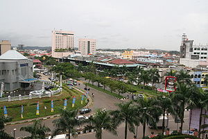
Batam
| Batam | ||
|---|---|---|
| View over the island | ||
| Waters | South China Sea | |
| Archipelago | Riau Islands | |
| Geographical location | 1 ° 5 ′ N , 104 ° 3 ′ E | |
|
|
||
| length | 29.4 km | |
| width | 25.1 km | |
| surface | 415 km² | |
| Residents | 1,153,860 2780 inhabitants / km² |
|
| main place | Batam | |
| Batam city | ||
Batam ( Indonesian Pulau Batam ) is the most populous of the Indonesian Riau Islands south of Singapore in the Malay Archipelago .
geography
Batam is located 20 km south of Singapore and Malaysia and 80 km northeast of Sumatra, which belongs to Indonesia . There are other islands of the Riau group in the vicinity: Bintan in the east, Rempang in the south and Bulan in the west - plus a large number of smaller islands.
Together with some of the islands it forms the Barelang archipelago (abbreviated from Batam-Rempang-Galang).
Batam belongs to the province of Kepulauan Riau and has an area of 415 km². The island forms part of the urban area of the metropolis Batam .
traffic
After Jakarta , the trip takes the ferry one day. Speedboats to Singapore leave every 30 minutes and the journey takes 30 minutes. There are various connections between two ferry ports in Singapore and 5 ferry ports on Batam.
Speedboats leave every 45 minutes to Johor Bahru (Malaysia), travel time 2 hours.
The Trans Barelang road leads over a 644 m long road bridge, completed in 1997, to the small, southern neighboring island of Tonton and over other bridges from Tonton to Nipah (420 m long and also completed in 1997), from Nipah to Setoko (270 m) and from Setoko to Rempang (365 m).
In the east of the island is the Hang Nadim International Airport , which was built in 1965 and handled 3.3 million passengers in 2006.
population
Batam has a population of over 1,200,000, with 85% Malay-Indonesian and 14% Chinese . Originally the main occupation was fishing and sea transport. The Orang Laut (sailors) live in houseboats or stilt houses on the sea.
Malay and Islamic influences characterize the culture, especially music and dance. Worth mentioning is the yogi dance, which can only be found on Batam, as well as the Arabic-influenced Zapin , Persembahan and Ronggeng dance.
economy
Tourism increased from 60,000 overnight stays in 1985 to 606,000 in 1991, with the majority of tourists coming from Singapore (74%) and Malaysia (10%).
Due to its proximity to the island state of Singapore and the Malaysian Johor Bahru , Batam has developed into an industrial center with an airport, a port and over 20 industrial parks in which over 170,000 people work.
In order to boost the economy, the Indonesian government has canceled environmental protection laws and waste and polluted soil from Singapore are being dumped on Batam. Prostitution, which is not tolerated in Singapore, has also spread in Batam.
The Indonesian state has transferred its control powers to the Batam Industrial Development Authority (BIDA), which is outside the local administrations. Most of the companies from Singapore conclude their contracts with the Salim Group . Both BIDA and Salim have close ties to the powerful in Indonesia, and nepotism has led to injustice and enrichment. For example, insufficient compensation was paid for land expropriations.
history
Batam was mentioned in Chinese chronicles as early as 231 AD. In the 13th century the island came under the rule of the Kingdom of Malacca , then the Sultan of Johor followed until the 18th century . The coastal towns across from Singapore were known as pirate hideouts.
The Dutch and British clarified their areas of influence in the British-Dutch Treaty of 1824 : Batam and the neighboring islands came to the Kingdom of Riau Lingga and were later taken over by the Dutch East India Company .
Batam has been part of Indonesia since independence in 1949.
In 1970 there were only 7000 people on the island and 98% of it was still covered with forest.
With the establishment of the Batam / Bintan / Karimun free trade zone in 1989, strong economic growth began - Singapore was the model. But the ambitious plans got a damper with the Asian economic crisis at the end of the 1990s.
Individual evidence
- ↑ a b c d The Newsletter 31 of the International Institute for Asian Studies (IAAS, Summer 2003). (PDF) (No longer available online.) Iias.nl, July 2003, archived from the original on May 17, 2014 ; accessed on June 17, 2015 . Info: The archive link was inserted automatically and has not yet been checked. Please check the original and archive link according to the instructions and then remove this notice.
- ^ Ferries from Singapore to Batam. Retrieved October 5, 2019 .
- ↑ Schedule BERJAYA WATERFRONT FERRY TERMINAL. Retrieved October 5, 2019 .
- ↑ Batam-Tonton Bridge. structurae.de , accessed on June 17, 2015 .
- ^ Tonton-Nipah Bridge. structurae.de , accessed on June 17, 2015 .
- ↑ Setoko Nipah Bridge. structurae.de , accessed on June 17, 2015 .
- ↑ Setoko-Rempang Bridge. structurae.de , accessed on June 17, 2015 .
- ↑ bpbatam.go.id Batam Indonesia Free Zone Authority. (No longer available online.) Archived from the original on November 9, 2016 ; accessed on July 23, 2017 .
- ↑ Welcome to Batam Island. batam.com, accessed June 17, 2015 .
- ↑ bpbatam.go.id Batam Indonesia Free Zone Authority. (No longer available online.) Archived from the original on May 20, 2017 ; accessed on July 23, 2017 .


