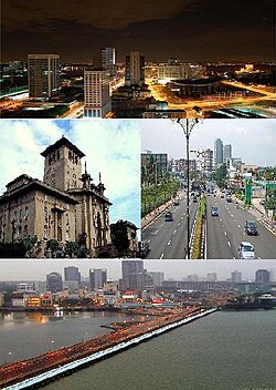
Johor Bahru
| جوهر بهرو Johor Bahru |
||
|---|---|---|
|
|
||
| Coordinates | 1 ° 29 ′ N , 103 ° 45 ′ E | |
| Symbols | ||
|
||
| Basic data | ||
| Country | Malaysia | |
| Johor | ||
| ISO 3166-2 | MY-01 | |
| height | 37 m | |
| surface | 185 km² | |
| Residents | 1,463,800 | |
| Metropolitan area | 2,374,778 | |
| density | 7,912.4 Ew. / km² | |
| Post Code | 80000 - 81800 | |
| Website | www.johordt.gov.my | |
| politics | ||
| mayor | Haji Mohd Jaffar Bin Awang | |
The port city of Johor Bahru (the "new jewel"; other spellings: Johore Bahru , Johor Baharu ) is a city in Malaysia on the southern tip of the Malay Peninsula , directly opposite the island of Singapore . Colloquially , the city in the region is referred to as " JB ".
Johor Bahru is the capital of the state of Johor and with around 1,500,000 inhabitants in the actual city and 2,400,000 people in the agglomeration with suburbs one of the economic centers of Malaysia.
Due to its proximity to Singapore, the city became a traffic hub with a high volume of trade.
Sights are the Sultan's palace , the park “Istana Garden Johor” as well as the Abu Bakar mosque, the Church of the Immaculate Conception and the Sri Mariamman Temple .
A considerable part of the water supply for Singapore comes from Johor Bahru by means of large pipelines via the "Causeway", a road embankment.
history
Johor Bahru was established in 1855 after the ruler of Johor, Temenggong Daing Ibrahim, moved the headquarters of the administration there. At the time, the place was known as Tanjung Puteri , a small Malay fishing village. Tanjung Puteri was then renamed on January 1, 1866 by Ibrahim's son and successor Temenggong Abu Bakar from Johor to Johor Bahru. Under Abu Bakar, Johor Bahru experienced rapid growth. During his reign the Abu Bakar Mosque, the Istana Besar and the Menteri Besar were built. The city also experienced a wave of Chinese immigrants during that time.
In the Battle of Malaya in World War II, the Japanese army captured the city on January 31, 1942 and the Sultan's residence became a planning center for the conquest of Singapore, the neighboring city of Johor Bahru. Shortly after the war, the city became a center of Malay nationalism. Johor Bahru became the founding site of the United Malay National Organization (UMNO), the dominant political force in the Barisan Nasional coalition .
In the 1960s the city experienced an economic boom. This led to the development of settlement areas and industrial establishments. Due to the steady growth, Johor Bahru was finally granted city status on January 1, 1994.
economy
In the mid-1990s, a central business district was built in the city center around the areas of Jalan Wong Ah Fook and the Johor – Singapore Causeway . The state of Johor and the Malaysian federal government support the economic program with state funds.
traffic
Senai International Airport, IATA code JHB, is the city's airport.
JB is a central hub for road traffic between Malaysia and Singapore.
Rail traffic is to be modernized in the next few years with a new high-speed rail link Singapore-Johor Bahru-Kuala Lumpur.
The Permas Jaya Bridge has existed since 1994 .
sons and daughters of the town
- Sultan Mahmud Iskandar Al-Haj (1932-2010), Yang di-Pertuan Agong (King of Malaysia) from 1984 to 1989
- Nauraj Singh Randhawa (* 1992), high jumper
Climate table
| Johor Bahru | ||||||||||||||||||||||||||||||||||||||||||||||||
|---|---|---|---|---|---|---|---|---|---|---|---|---|---|---|---|---|---|---|---|---|---|---|---|---|---|---|---|---|---|---|---|---|---|---|---|---|---|---|---|---|---|---|---|---|---|---|---|---|
| Climate diagram | ||||||||||||||||||||||||||||||||||||||||||||||||
| ||||||||||||||||||||||||||||||||||||||||||||||||
|
Monthly average temperatures and rainfall for Johor Bahru
|
|||||||||||||||||||||||||||||||||||||||||||||||||||||||||||||||||||||||||||||||||||||||||||||||||||||||||
Web links
Official website of the city of Johor Bahru (English)
Individual evidence
- ^ Historical Society, Universiti Malaya , Jernal Sejarah , p. 58.
- ↑ A physical symbol of loyalty and posterity ( Memento of the original dated February 12, 2009 in the Internet Archive ) Info: The archive link was inserted automatically and has not yet been checked. Please check the original and archive link according to the instructions and then remove this notice. , Fauziah Ismail, JohorBuzz, New Straits Times
- ↑ Lim: Wong Ah Fook: Immigrant, Builder and Entrepreneur. ISBN 981-230-198-4 , p. 99.
- ↑ Lim: Wong Ah Fook: Immigrant, Builder and Entrepreneur. P. 46.
- ^ Richard Reid, War for the Empire: Malaya and Singapore, Dec 1941 to Feb 1942 . Australia-Japan Research Project
- ↑ Kembali kepada Rakyat , Aznan Bakar, May 10th 2008, Utusan Malaysia
- ↑ Guinness, On the Margin of Capitalism: People and Development in Mukim Plentong, Johor, Malaysia , p. 177.
- ↑ Johor Bahru – Dataran Bandaraya Johor Bahru ( Memento of the original from February 25, 2009 in the Internet Archive ) Info: The archive link was inserted automatically and has not yet been checked. Please check the original and archive link according to the instructions and then remove this notice. , Portal Rasmi Kerajaan Negeri Johor Darul Ta'zim; Retrieved February 28, 2010
- ↑ Rancangan Malaysia Kesembilan (RMK-9: 2006-2010) , Pusat Maklumat Rakyat, accessed 28 February 2010


