Bear Creek, Alabama
|
|
This article was on the basis of substantive defects quality assurance side of the project USA entered. Help bring the quality of this article to an acceptable level and take part in the discussion ! A closer description on the resolving issues is missing. |
| Bear Creek | |
|---|---|
|
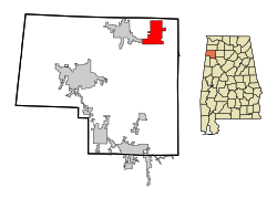
Location in county and state
|
|
| Basic data | |
| State : | United States |
| State : | Alabama |
| County : | Marion County |
| Coordinates : | 34 ° 16 ′ N , 87 ° 42 ′ W |
| Time zone : | Eastern ( UTC − 5 / −4 ) |
| Residents : | 1,070 (as of 2010) |
| Population density : | 30.6 inhabitants per km 2 |
| Area : | 35.6 km 2 (approx. 14 mi 2 ) of which 35.0 km 2 (approx. 14 mi 2 ) are land |
| Height : | 246 m |
| Postal code : | 35543 |
| Area code : | +1 205 |
| FIPS : | 01-04852 |
| GNIS ID : | 0154439 |
| Website : | www.townofbearcreek.com |
Bear Creek is a city in Marion County in the US state of Alabama . The place has a total area of 35.6 km².
geography
Bear Creek is located in northwest Alabama in the southern United States, about 35 kilometers east of the Mississippi border and 80 kilometers south of the Tennessee border . The place is about 15 kilometers west of the 733 square kilometers William B. Bankhead National Forest .
Nearby places include Hackleburg (1 km west), Haleyville (2 km east), Phil Campbell (4 km north), Hamilton (15 km southwest) and Hodges (17 km west). The next larger city with 170,000 inhabitants is Huntsville, about 90 kilometers northeast .
history
Before the Civil War , the place was known as Allen's Factory , based on a nearby textile factory. When the factory burned down during the war, the name of the nearby river was chosen as the city name. In the early 1880s, JR Phillips moved here and bought land that would later become the core of the current city.
In 1903 the city was largely destroyed by a fire, but was immediately rebuilt. In the early 20th century the city experienced its strong economic phase. When the Illinois Central Railroad built a railway line through neighboring Haleyville, the city increasingly lost its economic importance and large parts of its population.
traffic
Bear Creek is crossed by Alabama State Route 13 , Alabama State Route 172, and Alabama State Route 241 . US Highway 43 runs about 4 kilometers west, and US Highway 278 runs 12 kilometers south .
Approximately 4 kilometers east of the city is the Haleyville Airport, Posey Field , 15 kilometers north also the Russellville Municipal Airport and 25 kilometers southwest the Marion County - Rankin Fite Airport .
Demographics
As of the 2000 census , Bear Creek had 1,053 residents, distributed among 428 households and 309 families. The population density was 30.1 inhabitants / km². 99.15% of the population were white, 0.09% African American. Children under the age of 18 lived in 32.5% of households. The median income for a household was $ 27,813, with 18.2% of the population living below the poverty line.
By the 2010 census , the population rose to 1,070.
Web links
- Official website (English).
- Statistical data on Bear Creek (Engl.)
- Bear Creek in the Encyclopedia of Alabama (Engl.)
Individual evidence
- ↑ Missouri Census Data Center ( page no longer available , search in web archives ) Info: The link was automatically marked as defective. Please check the link according to the instructions and then remove this notice. , Retrieved October 12, 2012

