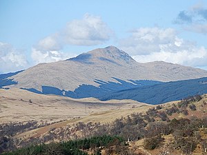
Beinn Bhuidhe
| Beinn Bhuidhe | ||
|---|---|---|
|
The Beinn Bhuidhe from the southwest, above Inveraray |
||
| height | 948 m ASL | |
| location | Argyll and Bute , Scotland | |
| Notch height | 592 m | |
| Coordinates | 56 ° 19 '36 " N , 4 ° 54' 25" W | |
|
|
||
The Beinn Bhuidhe or Ben Bhuidhe is a 948 meter high mountain in Scotland . Its Gaelic name means yellow hill . The mountain is located in a lonely moorland east of Loch Awe , west of the Arrochar Alps at the upper end of the valley of the in Loch Fyne leading Glen Fyne . He is classified as a Munro .
Its western location and height mean that the relatively steep and rocky summit of Beinn Bhuidhe is very exposed to the weather, but at the same time a very wide view over the entire western coastal area is possible. The highest point of the Beinn Bhuidhe lies in the southwest of the long summit ridge that runs from northeast to southwest. In the northeast, the ridge splits into two side ridges, each tapering into slightly lower tops.
Due to its isolated location and the long approaches it requires, the Beinn Bhuidhe is one of the Munros rarely visited by mountain hikers. The most frequented approach leads from Inverchorachan House in the upper part of Glen Fyne over the steep southeast side of the mountain range. Inverchorachan House is also an eight-kilometer walk through Glen Fyne from the settlement of Clachan on the A83 at the north end of Loch Fyne. There are other access options from the southwest from Glen Shira, which can be reached via Inveraray .
Individual evidence
Web links
- The Beinn Bhuidhe on walkhighlands.co.uk (English)
- The Beinn Bhuidhe on munromagic.com (English)


