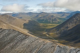
Bendeleben Mountains
| Bendeleben Mountains | ||
|---|---|---|
|
The western Bendeleben Mountains; View across the McKelvie Creek valley to the upper reaches of the Pargon River |
||
| Highest peak | Mount Bendeleben ( 1137 m ) | |
| location | Alaska (USA) | |
|
|
||
| Coordinates | 65 ° 15 ′ N , 162 ° 45 ′ W | |
The Bendeleben Mountains are a 110 km long and 45 km wide mountain range in the center of the Seward Peninsula in northwest Alaska .
With the 1137 m high Mount Bendeleben they reach their greatest height in the west. They are essentially made of granite and were glaciated during the last cold ages. They were eroded into round bumps by the glaciers . The Bendeleben Mountains are subdivided by the valleys of the Niukluk River , the Pargon River and the Boston Creek , which flow into the Fish River . The Fish River has its source in the east of the Bendeleben Mountains and drains southwest into Norton Sound , a bay in the Bering Sea . The soils are permafrost. The vegetation is characterized by arctic dwarf shrubs.
The Bendeleben Mountains were named after Ottfried von Bendeleben , who, as a participant and later leader of the Western Telegraph Expedition, first mapped large parts of the Seward Peninsula in 1866. Since Ottfried von Bendeleben spent his youth in the Thuringian town of Bendeleben , there is a connection between the mountain range and the village.
literature
Winfried Neumerkel: To the end of the world. From Thuringia to Mount Bendeleben in Alaska . 64 p., Bendeleben, 2009.

