Norton Sound
| Norton Sound Norton Sound |
||
|---|---|---|
|
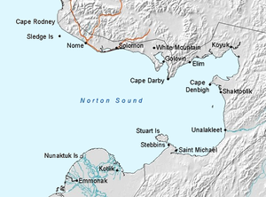
Map of Nortonsund |
||
| Waters | Bering Sea | |
| Land mass | North America | |
| Geographical location | 64 ° 0 ′ N , 163 ° 24 ′ W | |
|
|
||
| width | 200 km | |
| depth | 240 km | |
| Tributaries | Koyuk River | |
|
Sledge Island at the transition from the sound to the open sea |
||
The Norton Sound ( English Norton Sound ) is an inlet of the Bering Sea on the west coast of Alaska .
location
The sound lies south of the Seward Peninsula and protrudes 240 km into the mainland. It reaches a maximum width of 200 km. The southern boundary is the alluvial flat land of the Yukon Delta.
The rear part of the sound is bounded on the north by Cape Darby and on the south by Stuart Island . Here is Norton Bay , which is bounded by Cape Darby and Cape Denbigh and into which the Koyuk River flows, among other things . Besboro Island is located off the eastern coast of Nortonsund .
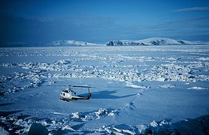
The sound is ice-free from June to October.
colonization
The first settlement took place by Indians . The sound forms the natural border between two North American peoples: the north coast was populated by the Inupiat , the south by the Yupik .
The strongest settlement took place on the northern coast of Nortonsund. The town of Nome, with a population of almost 4,000, is located at the entrance to the sound. This is followed by other small towns and villages up to Koyuk at the mouth of the river of the same name. To the east of the sound are Shaktoolik and Unalakleet . Near Stuart Island are Stebbins and Saint Michael . At the southwest end of Pastol Bay , at the southern entrance of the sound , lies Kotlik .


