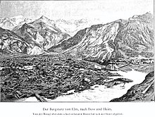
Rockslide from Elm


The Elm landslide on September 11, 1881 was a natural disaster in Elm, Switzerland, in the canton of Glarus .
prehistory
The landslide was largely due to the years of slate mining : The Elmer slate was soft and was ideally suited for the production of writing boards and pens . When compulsory schooling was introduced in the middle of the 19th century , this led to significantly higher sales of writing boards, especially in Germany. The mining of the slate was usually carried out by licensed companies; however, in 1878 the citizens of Elms decided to take the mining into their own hands.
Impoverished peasants inexperienced in mining promised themselves quick prosperity. As a result of their activities, the steep slope below the Plattenbergkopf was undermined by about 20 meters over a width of 180 meters and 65 meters at the deepest point, in particular the previously left supporting pillars in the valuable slate rock, which had stabilized the overburden, were dismantled. In the same year, 1878, movements in the mountain became increasingly noticeable. Heavy rainfalls in the summer of the unlucky year and the shift of the precipitation flowing off the slope area into the opening rock crevices led to an accelerated destabilization of the overburden. A commission arrived shortly before the catastrophe because of the increasing number of falling rocks and other massive changes in the landscape could not find any changes that would result in immediate dangers.
Landslide
The din of the falling rocks, smaller breaks and the formation of crevices was already perceived as disturbing on Sunday morning of September 11th, 1881 in the church service. Still, almost no one left the area. Many people even went to the affected area on purpose or climbed the Düniberg opposite to have an even better view.
Towards the late afternoon of September 11th, after two smaller advances every quarter of an hour, around 10 million cubic meters of slate broke off, fell 400 to 500 meters into the valley in free fall, crashed about 100 meters up on the opposite Düniberg - killing numerous spectators to pour into the Schwändi valley as a two-kilometer-long flat stream. 114 people were killed; 83 buildings were destroyed. A total of 90 hectares was destroyed and the slate mine was also completely destroyed.
The course and possible causes of the landslide were examined for the first time in the same year by the pastor Ernst Buss and the engineering geologist Albert Heim in the brochure Der Bergsturz von Elm .
literature
- Emil Zopfi : Kilchenstock. The landslide in the mind. Limmat, Zurich 1996, ISBN 978-3-85791-275-7 .
- Franz Hohler : The stone flood. A novella. DTV, 2000, ISBN 978-3-42312-735-6 . The novel has the rockslide as its background; he describes the last two days before the catastrophe from the perspective of the seven-year-old Katharina Rhyner-Disch (* 1874, † 1959). In the accident, she lost five siblings, a grandmother and both parents.
Individual evidence
- ^ "The landslide of Elm" ( Memento from October 11, 2016 in the Internet Archive ), website of Elm Tourism. Retrieved October 11, 2016.
- ↑ Karl Josef Witt (Ed.): Grundbau-Taschenbuch / Volume I / Geotechnical Basics , Verlag für Architektur und Technische Wissenschaften GmbH & Co. KG, Berlin, 2008, p. 743
- ↑ A man-made disaster. Neue Zürcher Zeitung, September 9, 2006, accessed on January 13, 2019 .
- ↑ Hans Georg Wunderlich: Introduction to Geology, Volume I, Exogenous Dynamics , Bibliographisches Institut Mannheim / Vienna / Zurich, BI-Wissenschaftsverlag, Mannheim, 1968, p. 69
- ↑ Herbert Louis and Klaus Fischer: Allgemeine Geomorphologie , de Gruyter, Berlin, 4th ed., 1979, p. 154
- ↑ Hans Georg Wunderlich: Introduction to Geology, Volume I, Exogenous Dynamics , Bibliographisches Institut Mannheim / Vienna / Zurich, BI-Wissenschaftsverlag, Mannheim, 1968, p. 69
- ↑ August Rothpletz: The Elm landslide in the journal of the German Geological Society, Volume 33, Issue 4, 1881, pp. 540-564