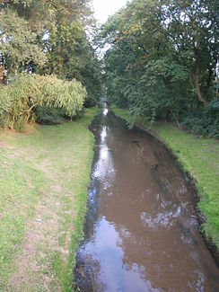
Biała (Supraśl)
|
Biała Białka |
||
|
The Biała in Białystok |
||
| Data | ||
| location | Poland | |
| River system | Vistula | |
| Drain over | Supraśl → Narew → Vistula → Baltic Sea | |
| Source height | 168 m npm | |
| muzzle | near the village of Fasty ( Gmina Dobrzyniewo Duże ) in the Supraśl coordinates: 53 ° 10 '42 " N , 23 ° 1' 37" E, 53 ° 10 '42 " N , 23 ° 1' 37" E |
|
| Mouth height | 115 m npm | |
| Height difference | 53 m | |
| Bottom slope | 1.6 ‰ | |
| length | 32.7 km | |
| Catchment area | 133.37 km² | |
| Big cities | Białystok | |
The Biała is a left tributary of the Supraśl , which in turn flows into the Narew , in Poland .
geography
The 32.7 km long river has its source in the village of Protasy ( Gmina Zabłudów ) in the Podlaskie Voivodeship and flows in a north-westerly direction through the city of Białystok and on until it flows into the Supraśl at the village of Fasty ( Gmina Dobrzyniewo Duże ). The catchment area is given as 133.37 km², the mean discharge with 1.2 m³ / s in Zawady (between Białystok and the mouth).
Web links
Commons : Biała - collection of images, videos and audio files

