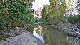
Big Sandy River (Bill Williams River)
| Big Sandy River | ||
|
The river on the northern border of the Arrastra Mountain Wilderness |
||
| Data | ||
| Water code | US : 1361 | |
| location | Arizona (USA) | |
| River system | Colorado River | |
| Drain over | Bill Williams River → Colorado River → Gulf of California | |
| source |
Knight Creek and Trout Creek , in La Paz Counties 34 ° 55 ′ 21 ″ N , 113 ° 37 ′ 37 ″ W |
|
| Source height | 740 m | |
| Union | with the Santa Maria River to the Bill Williams River Coordinates: 34 ° 18 ′ 38 " N , 113 ° 31 ′ 36" W 34 ° 18 ′ 38 " N , 113 ° 31 ′ 36" W |
|
| Mouth height | 377 m | |
| Height difference | 363 m | |
| Bottom slope | 2.8 ‰ | |
| length | 129 km | |
| Catchment area | 4900 km² | |
The Big Sandy River is a river in northwest Arizona in Mohave County .
It begins at the confluence of Knight Creek and Trout Creek on the Hualapai Indian Reservation near Hualapai Peak and then flows past Wikieup south of Kingman . After a length of 129 km it joins the Santa Maria River to the Bill Williams River , just before this flows through the Alamo Lake , a reservoir; when the water is completely blocked, the two source rivers flow directly into the lake. The Big Sandy River flows between the Hualapai Mountains to the west and the Juniper Mountains to the east, while the Mohon Mountains to the south and the Peacock Mountains and the Cottonwood Cliffs to the north .
Due to the dry climate, the Big Sandy River does not have water all year round. After rains it drains an area of around 4900 km². Much of the water is diverted to be used for mining purposes in the area.
The project to build a hydropower station on the river was dropped in 2001, on the one hand for ecological reasons, on the other hand because of complaints from the Hualapai Indians .
