Binselberg (Gerabronn)
|
Binselberg
City of Gerabronn
Coordinates: 49 ° 13 '59 " N , 9 ° 52' 45" E
|
|
|---|---|
| Height : | approx. 450 m above sea level NHN |
| Postal code : | 74582 |
| Area code : | 07952 |
|
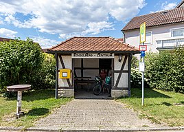
The bus stop in Binselberg
|
|
Binselberg (formerly also Binzelberg and Bynselberg ) is a hamlet in the Michelbach an der Heide district of the small town of Gerabronn in the Schwäbisch Hall district in the Franconian north-east of Baden-Württemberg .
geography
The place is in the Hohenlohe region , about 3.5 km southwest of the city center of Gerabronn and southeast of Langenburg . He stands at an altitude of about 440 to 460 m above sea level. NHN at the uppermost, still shallow slope to the river valley of the middle Jagst in the south, which flows about a kilometer from it to the west. From a natural perspective, Binselberg is located in the Bartenstein-Langenburger Platten sub -area of the Kocher-Jagst plains .
About 400 meters north-west of the town limits, a 1.5 km long stream rises on the plateau , which enters the Binselberger Klinge , which is a protected natural monument, between Binselberg and the spur of the Katzenstein castle ruin above the river valley in the west , and just before the Langenburg Talweiler Hürden Jagsttalgrund reached. A clump of small ditch channels on the southeastern edge of Binselberg and east of it feeds a smaller blade south of the village, which runs up from hurdles at the Gerabronner Talweiler Großforst and drains through it to the Jagst. These small bodies of water are all at least partially unstable.
Binselberg stands on the southern edge of the Lettenkeuper cap ( Erfurt formation ), which covers most of the Riedel between the Jagst valley in the west and south, that of its Brettach tributary in the east and the valley section of the last Brettach tributary Michelbach in the northeast. Immediately after the local border, the Upper Muschelkalk begins below , and further down the upper tree line of the steep Jagsttal slope follows the Middle Muschelkalk down to the valley floor. The creek troughs and blades partly follow short tectonic fault lines all southward.
description
The houses in Binselberg - there are fewer than three dozen house numbers - are lined up on both sides of the two connecting streets to the larger neighboring towns. The hamlet, which is still dominated by agriculture today, was surrounded almost everywhere by a soft patch of orchards, beyond which the fields began. This ring is now interrupted by the addition of larger agricultural buildings mainly on the outskirts. There is a small pond on the eastern edge of the village, an older one on the southern one seems to have been built over.
traffic
Two low-ranking roads from the L 1033 state road, which connects the two neighboring small towns, connect the hamlet on the plateau with the next towns of Langenburg in the north-west and Michelbach an der Heide in the north-east; , Holderhof and Brettachhöhe from Gerabronn.
history
Historically, Binselbach was first mentioned in 1357 as Bynselberg . Like Liebesdorf , it belonged to the municipality of Langenburg in the Oberamt Gerabronn of the Jagstkreis until 1850 .
In 1799 Binselberg had 53 inhabitants, spread over 8 houses, in 1839 49 people lived there.
Individual evidence
LUBW
Official online waterway map with a suitable section and the layers used here: Binselbach and the surrounding area
General introduction without default settings and layers: State Institute for the Environment Baden-Württemberg (LUBW) ( notes )
- ↑ Height according to the contour line image on the topographic map background layer .
- ↑ Length measured on the background layer topographic map .
- ↑ Protected areas according to the relevant layers, nature partly according to the biotope layer .
- ↑ Changes in the townscape after comparing the topographic map background layer with the measuring table sheet 6725 Gerabronn from 1938 in the Deutsche Fotothek
Other evidence
- ↑ a b Geographical Statistical-Topographical Lexicon of Franconia, 1799, 325 & q = Binzelberg + residents # v = onepage restricted preview in the Google book search
- ↑ Latest news from the Kingdom of Bavaria: 1813 limited preview in the Google book search
- ↑ Wolf-Dieter Sick : Geographical land survey: The natural space units on sheet 162 Rothenburg o. D. Deaf. Federal Institute for Regional Studies, Bad Godesberg 1962. → Online map (PDF; 4.7 MB)
- ↑ Geology according to the layers for Geological Map 1: 50,000 on: Map server of the State Office for Geology, Raw Materials and Mining (LGRB) ( notes )
- ↑ Königlich-Württembergisches Hof- und Staats-Handbuch: 1839 restricted preview in the Google book search
literature
- Topographic map 1: 25,000 Baden-Württemberg, as single sheet No. 6725 Gerabronn
Web links
- Map of Binselbach and the surrounding area on: State Institute for the Environment Baden-Württemberg (LUBW) ( Notes )
- Map of Binselbach and the surrounding area on: Geoportal Baden-Württemberg ( information )
- Binselberg at LEO-BW, the regional information system for Baden-Württemberg
- Measuring table sheet 6725 Gerabronn from 1938 in the Deutsche Fotothek
