Bitterroot chain
| Bitterroot chain
Bitterroot Range
|
||
|---|---|---|
|
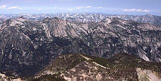
Part of the Bitterroot Range in Montana, looking north from El Capitan |
||
| Highest peak | Scott Peak ( 3474 m ) | |
| location | Idaho , Montana (USA) | |
| part of | Rocky mountains | |
|
|
||
| Coordinates | 46 ° N , 115 ° W | |
The Bitterroot Range ( English Bitterroot Range ) is an approximately 640 km long mountain range that stretches along the border between the US states of Idaho and Montana . The mountain range extends from Lake Pend Oreille in the northwest to Monida Pass in the southeast. He is part of the northern Rocky Mountains , and after was Bitterwurzart (Engl. Bitterroot , scientific name : Lewizia rediviva ) named. The peaks are on average 2700 m high, the highest mountain is Scott Peak in the Beaverhead Mountains with 3474 m . Of the 62,736 km² area, 6,475 km² are administered by the US Forest Service .
The Bitterroot Range is not to be confused with the Bitterroot Mountains , which form part of the mountain range. The Bitterroot Range comprises the following mountain ranges and mountain ranges (sorted from northwest to southeast):
swell
Web links
- Information about the mountains and the bitter root ( Memento from June 11, 2007 in the Internet Archive )
- List of mountains
- US Forest Service website
- Bitterrootkette on Peakbagger.com (English)
- Bitterroot Range in the Geographic Names Information System of the United States Geological Survey

