Black Cart Water
| Black Cart Water | ||
|
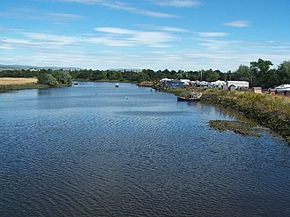
The Black Cart Water near the mouth |
||
| Data | ||
| location | Renfrewshire , Scotland | |
| River system | Clyde | |
| Drain over | Cart → Clyde | |
| source | Outflow from Castle Semple Hole 55 ° 48 ′ 19 ″ N , 4 ° 35 ′ 23 ″ W. |
|
| muzzle | Confluence with the White Cart Water at Renfrew Coordinates: 55 ° 52 ′ 59 ″ N , 4 ° 24 ′ 24 ″ W 55 ° 52 ′ 59 ″ N , 4 ° 24 ′ 24 ″ W.
|
|
| length | 14.5 km | |
The Black Cart Water is a river in Scotland .
geography
The Black Cart Water drains from the north end of Castle Semple Loch in the Renfrewshire Council Area . The river follows a north-easterly direction over its entire length of about 14.5 km. After three kilometers it passes the village of Howwood and then separates the towns of Johnstone and Kilbarchan from each other. Passing Linwood in the east, the White Cart Water receives its main tributary a short distance northeast with the Gryfe Water . The Black Cart Water borders Glasgow Airport to the west and flows 3.5 km below the confluence of the Gryfe at Renfrew with the White Cart Water to form the Cart . After a few hundred meters this flows into the Clyde .
Individual evidence
- ↑ a b Cart. In: Francis H. Groome: Ordnance Gazetteer of Scotland: A Survey of Scottish Topography, Statistical, Biographical and Historical. Volume 1: (A - Coru). Thomas C. Jack, Grange Publishing Works, Edinburgh et al. 1882, p. 246 .
- ^ White Cart Water. In: David Munro, Bruce Gittings: Scotland. An Encyclopedia of Places & Landscapes. Collins et al., Glasgow 2006, ISBN 0-00-472466-6 .

