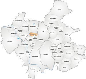
Blumenau (Winterthur)
|
Blumenau district of Winterthur |
|
|---|---|
| Coordinates | 695 891 / 262 616 |
| height | 431 m |
| surface | 0.43 km² |
| Residents | 4465 (Dec. 31, 2019) |
| Population density | 10'384 inhabitants / km² |
| BFS no. | 230-520 |
| Post Code | 8400 |
| Urban district | Veltheim (District 5) |
Blumenau is a district of the city of Winterthur . Together with the Rosenberg district, it forms urban district 5 ( Veltheim ).
geography
The Blumenau district represents the part of Veltheim located south of the Winterthur – Schaffhausen railway line and is relatively flat due to its location in the Eulach gravel plain. To the north of the railway line is the Rosenberg district, which also contains the historical core of the formerly independent municipality of Veltheim. The other boundaries of the quarter are largely congruent with the former boundary of the municipality of Veltheim. The border to the Wülflinger Quartier Oberfeld runs in the west along Flüelistrasse. In the south / south-west lies the Neuwiesen district , which is part of the Stadt district ; the border itself runs straight through populated areas and sometimes not even along roads. The quarter is divided into two parts by the busy Wülflingerstrasse, which runs from east to west.
education
The Blumenau district and the Veltheim district form part of the Veltheim-Wülflingen school district. The primary schools Wülflingerstrasse and Wiesenstrasse, both north of Wülflingerstrasse, are located in the area of the quarter. There is also a kindergarten at the Wiesenstrasse location. The Feld secondary school is located north of the railway line. Further schools such as the grammar school or vocational schools are located further in the city center.
history
The area of Blumenau was only slowly built over in the second half of the 19th century together with the growth of the city of Winterthur, with the area north of Wülflingerstrasse between the city of Winterthur and the Veltheim village center being tackled first. Development in this area intensified towards the end of the 19th century, so that by the turn of the century the quarter was already adjacent to Neuwiesen, which was developing around the same time. In 1930 the area was largely built over, even if not as dense as it is today.
Transport links
The quarter is accessed by trolleybus line 2 (Wülflingen – HB – Seen) in the direction of Wülflingen from the Winterthur city bus , which serves the quarter along Wülflingerstrasse at three to four stops. One stop is also named after the quarter itself.
On weekends, the night line N67 (Winterthur – Neftenbach – Pfungen – Dättlikon) runs along Wülflingerstrasse with a stop for getting off.
Culture and leisure
There are a few restaurants in the area, especially along Wülflingerstrasse. Right next to the district boundary in Oberfeld is the Flüeli, the home ground of SC Veltheim, as well as the Bioccodromo right next to it, which invites you to play boccia . Further cultural offers can be found in the city center, with which the district is easily accessible.

