Bogd Khan Uul
| Bogd Khan Uul | ||
|---|---|---|
|
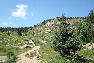
South slope Bogd Khan Uul with Manchir Chiid monastery |
||
| height | 2261 m | |
| location | Tow-Aimag , Mongolia | |
| Mountains | Chentii Mountains | |
| Coordinates | 47 ° 48 '14 " N , 106 ° 59' 11" E | |
|
|
||
| particularities | sacred mountain | |
The Bogd Khan Uul ( Mongolian Богд хан уул ) is a 2261 m high mountain in Mongolia . It is located south of the capital Ulaanbaatar , which it towers 914 meters above.
National park
The Bogd Khan Uul is considered the oldest continuously protected nature park in the world. As early as the twelfth and thirteenth centuries, logging and hunting were forbidden as this mountain was considered a sacred site. In 1778, the rulers of the Qing Dynasty declared the mountain a protected area . In the time of socialism it was formally elevated to a national park, which prevented sprawl of the countryside south of the capital.
The national park with an area of 67,300 hectares has been registered as a UNESCO biosphere reserve since 1996 . The north side is overgrown with a coniferous forest, on the south side rocks and grass dominate the landscape. The Siberian musk deer ( Moschus moschiferus ), the roe deer ( Capreolus capreolus ), the sable ( Martes zibellina ) and the mountain hare ( Lepus timidus ) inhabit this area.
location
From the place Zuunmod run trails to the summit. The city with the Manschir Chiid monastery is located at the southern foot of the Bogd Khan Uul and is about an hour's drive from Ulaanbaatar.
Individual evidence
- ↑ blog.nature.org: The World's Oldest National Park: Ghosts of Monks and Red Deer .
- ↑ The list of UNESCO biosphere reserves
- ^ MAB Biosphere Reserves Directory .


