Boliney
| Municipality of Boliney | ||
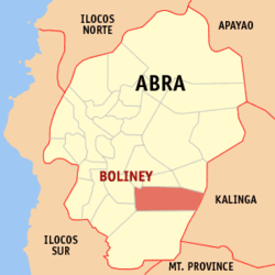
| Location of Boliney in the province of Abra | ||
|---|---|---|

|
||
| Basic data | ||
| Region : | Cordillera administrative region | |
| Province : | Abra | |
| Barangays : | 8th | |
| District: | 1. District of Abra | |
| PSGC : | 140102000 | |
| Income class : | 5th income bracket | |
| Households : | 639 May 1, 2000 census
|
|
| Population : | 3,573 August 1, 2015 census
|
|
| Population density : | 20.3 inhabitants per km² | |
| Area : | 176.40 km² | |
| Coordinates : | 17 ° 24 ' N , 120 ° 48' E | |
| Postal code : | 2815 | |
| Website: | www.boliney.gov.ph | |
| Geographical location in the Philippines | ||
|
|
||
Boliney is a municipality in the Province of Abra, Philippines .
geography
Boliney is located in the north of the island of Luzon about 345 km north of Manila and about 50 km southeast of Bangued . The area is 646 to 2286 meters above sea level .
Boliney has two distinct seasons, a dry season from November to April and a rainy season during the rest of the year. The average annual rainfall is 3100 mm to 4100 mm, the annual average temperatures are between 25.5 ° C and 28.8 ° C.
Barangays
Boliney is politically divided into eight barangays .
|
|
|
Population structure and development
The vast majority of the inhabitants belong to the Tinggian ethnic group , there are also small minorities from Bontok , Ilocano , Kalinga , Kankanaey , Kapampangan and Tagalog .
Economy and Infrastructure
Two of the eight Baranggay and about 1/6 of all households are connected to the electricity grid. The literacy rate is 79.8%, there are a total of 30 mostly single-class schools.
Attractions
- Bani Waterfalls, in the village of Bani about 32 km from the main town of Boliney
- Mt. Pusuey National Park
- Bani Hot Spring
