
Ogasawara-guntō
| Ogasawara-guntō | ||
|---|---|---|
 |
||
| Waters | Pacific Ocean | |
| Geographical location | 27 ° 10 ′ N , 142 ° 12 ′ E | |
|
||
| Number of islands | 41 | |
| Main island | Chichi-jima and Haha-jima | |
| Total land area | 73 km² | |
| Residents | 2821 (2009) | |

Ogasawara-guntō ( Japanese. 小 笠原 群島 , dt. "Ogasawara archipelago"), also Bonin Islands , is a Japanese archipelago located about 1000 kilometers southeast of the Japanese main island Honshū and adjoins the Izu Islands to the south .
The name Bonin Islands is a derivation of French cartographers from the Japanese munin (German: "without people") = "no man's islands ". The island chain belongs to the municipality of Ogasawara , the only municipality in the sub-prefecture of the same name within Tokyo prefecture . The entirety of the islands belonging to this municipality are also known under the collective name Ogasawara Islands (Japanese Ogasawara-shotō ).
history
The Bonin Islands (more precisely the southern Hahajima island chain) were probably discovered on October 2, 1543 by the Spanish navigator Bernardo de la Torre , who called them Forfana . The first Japanese contact with the islands dates from 1670, while the supposed discovery of 1543 cannot be proven.
The Dutch navigators Quast and Tasman sighted the Bonin Islands in 1639 and named them Gracht . The archipelago consists of three groups that are separated by deep channels and extend over a total of about 73 km² . The islands as such are all small and, despite the many steep mountains, are suitable for agricultural use in the green valleys.
Initially uninhabited, around 1830 a small settlement of sailors and Hawaiians emerged on Peel Island ( Chichi-jima ). This settlement was mainly used to supply the whale catcher with food. In January 1862 the Japanese Tokugawa shogunate colonized the Bonin Islands and named them "Ogasawara Islands" after the legendary explorer from the late 16th century. The colonization was an attempt by the Schogunate to assert itself internationally and to acquire modern whaling technologies through the exchange with the local whalers. From 1876 the archipelago became part of the Japanese national territory. After Japan surrendered in August 1945, the Bonin Islands were administered by the United States until they were returned to Japan in June 1968 .
geography
Ogasawara-guntō consists of the following island chains and islands with a total land area of 73 km², each arranged from north to south and west to east (rocks ( iwa ) are not listed with a few exceptions):
-
Mukojima Island Chain ( 聟 島 列島 , Mukojima-rettō ) (6.57 km²)
- Muko-jima ( 聟 島 , literally: "Bridegroom Island", 27 ° 41 ′ N , 142 ° 8 ′ E ) (2.57 km²)
- Kita-no-shima ( 北 之 島 , literally: "northern island", 27 ° 43 ′ N , 142 ° 6 ′ E ) (0.19 km²)
- Naka-no-shima ( 中 ノ 島 , literally: "middle island", 27 ° 43 ′ N , 142 ° 7 ′ E )
- Sasago-jima ( 笹魚島 , 27 ° 43 ' N , 142 ° 7' O )
- Tori-shima ( 鳥島 , literally: "Bird Island", 27 ° 41 ′ N , 142 ° 8 ′ E )
- Hari-no-iwa ( 針 之 岩 , literally: "fish hook rock", 27 ° 40 ′ N , 142 ° 9 ′ E )
- Nakōdo-jima ( 媒 島 , literally: "
- Tori-shima ( 鳥島 , literally: "Bird Island", 27 ° 37 ′ N , 142 ° 10 ′ E )
- Yomejima island chain ( 嫁 島 列島 , Yomejima-rettō )
- Yome-jima ( 嫁 島 , literally: "Bride Island", 27 ° 30 ′ N , 142 ° 13 ′ E ) (0.85 km²)
- Mae-jima ( 前 島 , literally: "front island", 27 ° 29 ′ N , 142 ° 12 ′ E )
- Ushiro-jima ( 後 島 , literally: "back island", 27 ° 30 ′ N , 142 ° 13 ′ E )


- Chichi-jima ( 父 島 , literally: "Father Island", 27 ° 4 ′ N , 142 ° 13 ′ E ) (23.99 km²)
- Mago-jima ( 孫 島 , literally: "grandchildren island", 27 ° 12 ′ N , 142 ° 12 ′ E )
- Otōto-jima ( 弟 島 , literally: "little brother island", 27 ° 10 ′ N , 142 ° 11 ′ E ) (5.30 km²)
- Ani-jima ( 兄 島 , literally: "Big Brother Island", 27 ° 7 ′ N , 142 ° 13 ′ E )
- Hyōtan-jima ( 瓢 箪 島 , literally: "Pumpkin Island", 27 ° 8 ′ N , 142 ° 11 ′ E )
- Nishi-jima ( 西 島 , literally: "West Island", 27 ° 7 ′ N , 142 ° 10 ′ E ) (0.49 km²)
- Hitomaru-jima ( 人 丸 島 , 27 ° 7 ′ N , 142 ° 11 ′ E )
- Nakadōri-jima ( 中 通 島 , literally: "middle-way island", 27 ° 6 ′ N , 142 ° 12 ′ E )
- Higashi-jima ( 東 島 , literally: "East Island", 27 ° 6 ′ N , 142 ° 15 ′ E ) (0.28 km²)
- Tatsumi-jima ( 巽 島 , literally: "Southeast Island", 27 ° 3 ′ N , 142 ° 14 ′ E )
- Tate-jima ( 縦 島 , literally: "vertical island", 27 ° 3 ′ N , 142 ° 11 ′ E )
- Kannuki-jima ( 閂 島 , literally: "Riegel-Insel", 27 ° 3 ′ N , 142 ° 11 ′ E )
- Minami-jima ( 南島 , literally: "South Island", 27 ° 2 ′ N , 142 ° 11 ′ E ) (0.34 km²)
- Reigan-jima ( 霊岸島 , literally "soul Shore island", 27 ° 2 ' N , 142 ° 11' O )

- Haha-jima ( 母 島 , literally: "Mother Island", 26 ° 40 ′ N , 142 ° 10 ′ E ) (20.80 km²)
- Katsuodori-Shima ( 鰹鳥島 , literally " Braun Tölpel -Insel", 26 ° 36 ' N , 142 ° 11' O )
- Okatsudori-jima ( 小 鰹 鳥島 , literally: "little brown booby island", 26 ° 36 ′ N , 142 ° 10 ′ E )
- Nakakatsuodori-jima ( 中 鰹 鳥島 , literally: "middle brown booby island", 26 ° 36 ′ N , 142 ° 11 ′ E )
- Mukō-jima ( 向 島 , literally: "opposite island", 26 ° 36 ′ N , 142 ° 8 ′ E ) (1.45 km²)
- Maru-jima ( 丸 島 , literally: "round island", 26 ° 36 ′ N , 142 ° 10 ′ E )
- Futago-jima ( 二 子 島 , literally: "twin child island", 26 ° 35 ′ N , 142 ° 10 ′ E )
- Hira-jima ( 平 島 , literally: "flat island", 26 ° 35 ′ N , 142 ° 9 ′ E ) (0.60 km²)
- Mei-jima ( 姪 島 , literally: "Niece Island", 26 ° 34 ′ N , 142 ° 14 ′ E ) (1.13 km²)
- Tori-shima ( 鳥島 , literally: "Bird Island", 26 ° 34 ′ N , 142 ° 14 ′ E )
- Yagi-shima ( 野羊 島 , literally: "wild goat island", 26 ° 34 ′ N , 142 ° 13 ′ E )
- Imōto-jima ( 妹 島 , literally: "little sister island", 26 ° 33 ′ 34 ″ N , 142 ° 12 ′ 34 ″ E ) (1.36 km²)
- Tori-shima ( 鳥島 , literally: "Bird Island", 26 ° 33 ′ N , 142 ° 12 ′ E )
- Kitatori-shima ( 北 鳥島 , literally: "northern bird island", 26 ° 34 ′ N , 142 ° 10 ′ E )
- Ane-jima ( 姉 島 , literally: "Big-Sister-Island", 26 ° 33 ′ 15 ″ N , 142 ° 9 ′ 25 ″ E ) (1.67 km²)
- Minamitori-shima ( 南 鳥島 , literally: "southern bird island", 26 ° 32 ′ N , 142 ° 9 ′ E )
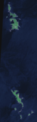
![]() Map with all coordinates of the geography section : OSM
Map with all coordinates of the geography section : OSM
Chichi-jima and Haha-jima are the only inhabited islands, with a population of around 2000 and 440 respectively. Muko-jima was also inhabited until the Second World War , in 1939 with a population of 46. Sugar cane , pineapples , and bananas are found on the islands and, on an experimental basis, in the 1980s, cultivated coffee. There are also precious woods; in particular, cedar, beech, boxwood, rose and sandalwood are exported.
Today the islands are among the most isolated parts of Japan, as they can only be reached by a 24-hour boat trip. The liners leave Tokyo twice a week. The Japanese construction industry and politicians have long been calling for an airport to be built, but the local population is skeptical about it.
Occasionally the small island of Nishinoshima ( 27 ° 15 ′ N , 140 ° 52 ′ E ), also known as Rosario Island , is part of the Bonin Islands, 130 km west of Chichi-jima . This is geographically incorrect, as this island is separated from the Bonin Islands by the Ogasawara trough, which is more than 4000 meters deep, and lies on the same submarine threshold as the Kazan-rettō island chain further south .
geology
The rock is named boninite after the islands .
gallery
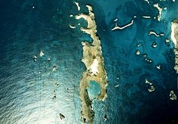
Chichijima and Hahajima

Mukō-jima

Nakadōri-jima

Yome-jima
Minami-jima

Ane-jima

Imōto-jima

Futami-kō (formerly Port Lloyd), the natural harbor basin on Chichi-jima


Web links
- further, partly deviating area information ( Memento from February 4, 2006 in the Internet Archive ) (PDF; 861 kB)
literature
- Rüegg, Jonas: "Mapping the Forgotten Colony: The Ogasawara Islands and the Tokugawa Pivot to the Pacific." In: Cross-Currents vol. 6 (2), 2017, 440-490.
- Goldschmidt, Prof. Dr. Richard; The descendants of the ancient settlers on the Bonin Islands; MOAG Volume XXII (1928 + 1931), Part B, pp. B1-B9
- Hyman Kublin: The Bonin Islands, 1543-1875. Harvard University, Cambridge 1947 (PhD thesis)
- Nobuo Muroga: Geographical exploration by the Japanese. In: Herman R. Friis (Ed.): The Pacific Basin. A history of its geographical exploration. New York 1967
Remarks
- ^ Jonas Rüegg: Mapping the Forgotten Colony: The Ogasawara Islands and the Tokugawa Pivot to the Pacific . (PDF) Cross-Currents, vol 6 (2), 2017, pp. 440–490 , accessed on November 24, 2018 (English).
- ↑ 7 章 エ リ ア 別 計画 . (PDF) Ogasawara village, archived from the original on February 4, 2006 ; Retrieved August 4, 2016 (Japanese, supplemented with Yahoo Maps).
- ↑ 世界 遺産 一 覧 表 記載 推薦 書 (素 案) 小 笠原 諸島 . (PDF) Japanese Ministry of the Environment, Forests and Fields Administration Office and Art and Culture Office, May 2009, p. 7 , accessed July 21, 2016 (Japanese).
- ^ Neal M. Bowers: The Mariana, Volcano, and Bonin Islands . In: Otis W. Freeman: Geography of the Pacific . 1951, p. 233