
Borberg (earth)
| Borberg
Castle Hill
|
||
|---|---|---|
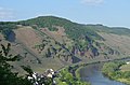
 Castle hill with sundial and remnants of Orley Castle |
||
| height | 360.3 m above sea level NHN | |
| location | Erden , Rhineland-Palatinate , Germany | |
| Coordinates | 49 ° 59 '6 " N , 7 ° 1' 17" E | |
|
||

The Borberg (also Burgberg ) is 360 m above sea level. NHN high elevation at the transition from the southern Eifel to the Moselle valley . Two castles were built on its slopes in the 10th century.
location
The Borberg is located in the municipality of Erden , east of Ürzig , at the southern end of the Eifel and the Wittlich valley at the transition to the Moselle valley.
The Burgberghütte is not far from the highest point.
history
The Borberg (castle hill) got its name from the fact that two castles were built on it in the 10th century AD. On the one hand the castle of the Orley family on the rock and on the other hand the castle of the Leyen family on the mountainside towards Ürzig.
On the morning of May 18, 1066, Count Theoderich (Burgrave of Leyen Castle) and his men attacked the Archbishop of Trier Kuno I von Pfullingen and took him prisoner. Kuno was then abducted eastwards to Leyen Castle and imprisoned. After two weeks of imprisonment, four warriors received the order on June 1, 1066 to murder Kuno. After falling three times from a ledge near the castle and still alive, Kuno was beheaded. His body remained unburied for the next 30 days until farmers from the village of Lösnich found him.
photos

Ürziger sundial with a statue of Kunos I von Pfullingen
Castle hill from the west


Individual evidence
- ↑ "Mosel Trödler": Burgberghütte. Panoramio, August 13, 2008, accessed on September 10, 2015 (photo only, no explanations).
- ↑ Entry on Ürziger sundial in the database of cultural assets in the Trier region ; accessed on March 11, 2016.