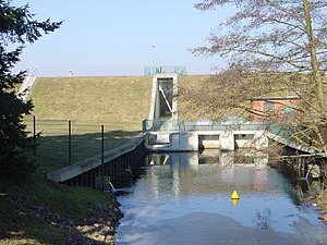
Dossespeicher Kyritz
| Dossespeicher Kyritz | ||
|---|---|---|

|
||
| Dam with outlet structure | ||
| Geographical location | Kyritz chain of lakes , Brandenburg | |
| Tributaries | Plumber | |
| Drain | Plumber → Dosse | |
| Data | ||
| Coordinates | 52 ° 58 '7 " N , 12 ° 26' 15" E | |
|
|
||
| Altitude above sea level | 40.5 m above sea level NHN | |
| surface | 2.68 km² | |
| volume | 9.8 million m³ | |
| Maximum depth | 11.5 m | |
| Middle deep | 5.5 m | |
| Data from the 2007 Statistical Yearbook | ||
The Dossespeicher Kyritz is also known as the Kyritz dam, Borker See or Obersee of the Kyritz chain of lakes . The Dossespeicher is located in the northwest of the state of Brandenburg .
The dossier was put into operation in 1979. It dams the Klempnitz, a tributary of the Dosse in the catchment area of the Havel . Its main purpose is to provide water for irrigation . This will irrigate around 11,000 hectares of agricultural land.
According to the 2007 statistical yearbook, the reservoir has a water surface of 2.68 km², a maximum water depth of 11.5 m and an average depth of 5.5 m. (According to the list of lakes, dams and reservoirs of the state of Brandenburg, these are: Water surface: 3.4 km², mean water depth 3.8 m.)
Its reservoir level is normally between 40.50 m above sea level. NHN and 38.50 m above sea level NHN. In dry years it is a drop down to 38.00 m above sea level. NHN possible and in the event of a flood a damming up to 41.00 m above sea level NHN. The area between 40.50 m above sea level. And 41.00 m above sea level NHN serves as a flood retention area , which has a volume of approx. 1.8 million m³. The storage capacity is 16.6 million m³, which is currently limited to 9.8 million m³. During floods it is up to approx. 18.3 million m³. The operating room contains 6.5 million m³ of water.
The dam has an approx. 5 m high and approx. 900 m long curved dam as a barrier structure .
Water from the Dosse can be transferred to the reservoir via the 5.3 km long Dossespeicher feeder . It is designed for a discharge of 3.1 m³ / s. To distribute the water, the Dosse-Jäglitz feeder (2.5 kilometers, 2.1 m³ / s) to the Jäglitz and the Dosse-Rhin feeder (8.1 kilometers, 1.0 m³ / s) to the Rhin were laid. The supply lines were partly built as a new building, partly by expanding existing trenches.
See also
Web links
Individual evidence
- ↑ Manfred Simon: Water supply for agricultural irrigation. In: Manfred Simon, Karl-Heinz Zwirnmann: Water management in the GDR. Published by the Water Management Working Group at the Institute for Environmental History and Regional Development eV at the University of Neubrandenburg, Edition Bookmark, Friedland 2019, ISBN 978-3-941681-50-7 , pp. 242-272, here p. 261.

