
Bridge over the Žepa

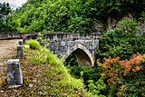
The Bridge over the Žepa ( Serbo-Croatian Most na Žepi / Мост на Жепи) is an Ottoman stone arch bridge over the Žepa River . Today it is located about 500 m south of the town of the same name in the east of Bosnia and Herzegovina , not far from the Redžep-pašina kula defense tower , and spans a narrow gorge of the river here at a height of about 14 meters .
history
The stone arch bridge was built in the last quarter of the 16th century, probably shortly after the great Drina bridge in nearby Višegrad . Like this, it was commissioned by the Ottoman Grand Vizier Sokollu Mehmed Pascha (Mehmed Paša Sokolović) and built by Mustafa-čauš, a student of Mimar Sinan . Its architectural style is very similar to that of the Višegrad bridge.
The bridge was originally located near the village of Slap at the mouth of the Žepa and the Drina and was part of the traffic route that led from Višegrad along the left bank of the Drin to the north. During the construction of the dam Bajina Basta that the Perućac lake dams, the old site was flooded. Due to its historical and architectural value, the bridge was dismantled in 1966 and rebuilt at its current location until 1968. Despite its location in the embattled Bosniak enclave Žepa, the bridge was not damaged in the Bosnian war .
The bridge is considered endangered. In 2016, the first safety measures were initiated and the bridge arch supported. The US Embassy in Bosnia contributed US $ 62,600 from its Heritage Preservation Fund.
literature
Ivo Andrić wrote the historical story Most na Žepi , which appeared in a volume of the same title in 1925. The German translation appeared in 1963 as The Bridge over the Žepa .
gallery

Bridge deck
View of the north approach
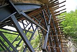
Safeguards under the bridge

View of the river

Information board with schematic drawings


swell
- Information board on the bridge
Individual evidence
- ^ Reconstruction of the National Monument - Bridge on River Zepa have started. Sarajevo Times, October 5, 2016, accessed June 25, 2018 .
- ↑ Počela re Konstrukcija nacionalnog spomenika - Mosta na rijeci Žepi. klix.ba, October 4, 2016, accessed June 27, 2018 (Bosnian).
Web links
Coordinates: 43 ° 56 ′ 54.8 ″ N , 19 ° 8 ′ 12.2 ″ E