
Bommel Bridge
Coordinates: 51 ° 49 ′ 6 ″ N , 5 ° 15 ′ 39 ″ E
|
|
||
|---|---|---|
 Bommel Bridge, Dr. W. Hupkes Bridge |
||
| Convicted | Rijksweg 2 | |
| Crossing of | Waal | |
| place |
Zaltbommel , Waardenburg ( West Betuwe municipality ) |
|
| construction | Truss bridge | |
| overall length | 913 m | |
| Longest span | 3 × 127 m | |
| start of building | January 18, 1931 | |
| opening | November 18, 1933 | |
| Status | Demolished in 2007/2008 | |
| closure | 1996 | |
| location | ||
|
||

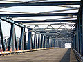
The Bommel Bridge ( Dutch Bommelse Brug ) spanned the Waal , the southern arm of the Rhine in the Rhine-Maas Delta, between the Dutch municipalities of Zaltbommel and West Betuwe from 1933 to 2008 . The Rijksweg A2 and a path for cyclists and pedestrians ran on the truss bridge. In January 1996 the structure was replaced by the Martinus-Nijhoff Bridge and removed in 2007/2008. The bridge was located at Rhine kilometer 933.55 and kilometer 75.20 of the Dutch waterway 101 (Rhine – Waal – Boven-Merwede – Beneden- Merwede – Noord ).
history
The bridge was built as a result of the Rijkswegenplan drawn up in 1927 , which included the construction of 12 road bridges over the major Dutch rivers. On January 18, 1931, construction work on the 913 meter long structure began. On November 18, 1933, the first permanent road bridge over the Waal was opened by Queen Wilhelmina in the presence of numerous spectators. The structure had an 11 meter wide concrete roadway and 2 × 2 meter wide bicycle and pedestrian paths. The planners around chief engineer WJH Harmsen von Rijkswaterstaat based the length and number of the truss spans on the neighboring railway bridge . The three main spans at the southern end had a span of 127 meters each. The eight spans of the approach bridge had a span of about 60 meters each. The steel frame had a total weight of 8.6 million kilograms. The framework was held together by around two million rivets.
In 1934, the poet Martinus Nijhoff (1894–1953) wrote the line in his sonnet De moeder de vrouw : “Ik went naar Bommel om de brug te zien” (German “I went to Bommel to see the bridge” ). At the beginning and towards the end of the Second World War , the bridge was supposed to be brought down with explosives. The slim-looking, but robust structure was badly damaged in the process, but could be rebuilt in both cases.
From the 1980s onwards, the building became a serious obstacle to traffic due to increasing car traffic. In 1994, 596 traffic jams were registered on the bridge. More than 80,000 vehicles now roll over one of the most important north-south connections in the Netherlands every day. The bridge, on which a maximum speed of 100 km / h was permitted, had two directional lanes without a central barrier . Mainly because of this, numerous traffic accidents occurred here. From 1993 to January 1996, a modern cable-stayed bridge was built west of the overloaded old building , which was named after the poet Nijhoff.
Several citizens' groups tried to save the disused old bridge from demolition. It was requested that the bridge be added to the list of Rijksmonumente and that it be made accessible to pedestrians and cyclists. But on April 13, 2007, more than ten years after the opening of the new building, work began on dismantling the Bommelse Brug . In 2008 the demolition was completed. The recycling of the steel was taken over by the Corus company. On November 23, 2009, a memorial was unveiled at the former location, commemorating the old bridge.
Picture gallery

Fatal traffic accident on the bridge, 1991

Construction of the Martinus Nijhoff Bridge, 1993
Disused bridge, 2005

Demolition work, 2007


See also
Web links
|
The next bridge upstream: Waal : Dr.-W.-Hupkes-Brücke |
Bridges over the Rhine |
The next bridge downstream: Waal : Martinus-Nijhoff-Brücke |