Brjanta
|
Brjanta Брянта |
||
|
|
||
| Data | ||
| Water code | RU : 20030400112118100026316 | |
| location | Amur Oblast ( Russia ) | |
| River system | Amur | |
| Drain over | Seja → Amur → Tatar Sound | |
| confluence | from Bolschaja Brjanta and Malaja Brjanta in the Stanovoi Mountains 55 ° 38 ′ 21 ″ N , 127 ° 40 ′ 17 ″ E |
|
| muzzle |
Seja Reservoir Coordinates: 54 ° 31 ′ 53 ″ N , 127 ° 26 ′ 1 ″ E 54 ° 31 ′ 53 ″ N , 127 ° 26 ′ 1 ″ E
|
|
| length | 317 km | |
| Catchment area | 14,100 km² | |
|
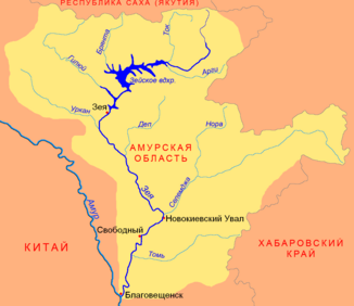
Location of the Brjanta (Брянта) in the catchment area of the Seja |
||
The Brjanta ( Russian Брянта ) is a right tributary of the Seja in the Amur Oblast in the Far East of Russia .
The Brjanta arises on the southern flank of the Stanovoi Mountains at the confluence of its two source rivers Bolschaja Brjanta (14 km, right) and Malaja Brjanta (left). It flows in a predominantly southerly direction through the Upper Seja Plain ( Верхнезейская равнина ) and after 317 km flows into the Seja, which is dammed up to form the Seja reservoir . The catchment area of the Brjanta covers 14,100 km².
Individual evidence
- ↑ a b Article Brjanta in the Great Soviet Encyclopedia (BSE) , 3rd edition 1969–1978 (Russian)
- ↑ a b Brjanta in the State Water Register of the Russian Federation (Russian)
