
Brucker Lache
|
Brucker Lache
|
||
 Location map |
||
| location | Erlangen , Bavaria | |
| surface | 111.417 ha | |
| Identifier | NSG-00199.01 | |
| WDPA ID | 162592 | |
| Geographical location | 49 ° 34 ' N , 11 ° 1' E | |
|
||
| Setup date | 1964 | |
| administration | gain | |

The Brucker Lache is a forest in the city of Erlangen . It is located east of the Bruck district and north of Tennenlohe . The forest has been part of the 322.4 hectare nature reserve "Brucker Lache mit Langenaufeld" since 1983. Its core area (76 ha) is the “Brucker Lache” nature reserve , which was designated as the first nature reserve in Central Franconia in 1964 .
history
Although the wetland north of the Erlangen district of Tennenlohe was classified as worthy of protection early on, extensive construction measures such as roads and housing developments were planned in the area until the end of the 1960s. It was not until the emergence of environmental awareness at the beginning of the 1990s that the construction that had already started on today's tree line stopped.

In 1978 a 30 hectare part of the nature reserve was designated as a forest reserve. In this part, which is particularly worthy of protection, swamps and moors as well as the alder-ash forest ( quarry forest ) that are characteristic of these biotopes have formed due to impermeable clay and loam layers .
In order to secure the sensitive water balance of this biotope and thus the nature reserve itself in the long term, the nature reserve was enlarged by a further 110 hectares in 1984 and one year later the entire Brucker Lache was declared a forest.
The straight Franzosenweg, which was laid out in 1820 as part of the Bavarian land survey, runs right through the nature reserve in order to have a direct line of sight between the towers of the Tennenloh Church of St. Maria Magdalena and the Huguenot Church . After the Second World War , the view of the church towers was blocked on both sides.
On the southern edge of the nature reserve is the Tennenlohe Forest Experience Center , one of five forest experience centers of the Bavarian Forest Administration .
gallery

Aerial view of the forest area Brucker Lache on the right (331 ha) and the creek ditch on the left (9 ha)
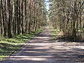
The Franzosenweg leads right through the NSG

The core of the Brucker Lache is under nature protection

The Mühlgraben rises in the Brucker Lache and flows into the Regnitz


Web links
Individual evidence
- ↑ Green List of Landscape Protection Areas in Middle Franconia , accessed on August 4, 2015.
- ↑ Green List, Nature Reserves , accessed on August 4, 2015.