Brunskappel
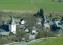
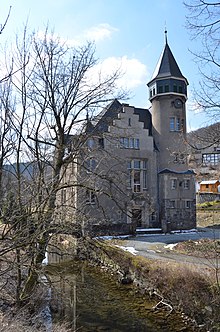
Brunskappel is a district of the city of Olsberg in the Hochsauerlandkreis . The village had 240 inhabitants as of December 30, 2017 and is surrounded by mountains in the Negertal. The village center is characterized by many half-timbered houses up to 400 years old, the Romanesque church, which was redesigned in baroque style after a fire, and Wildenberg Castle, built in 1907.
geography
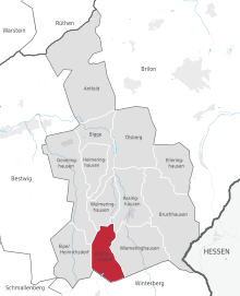
The neighboring towns of Brunskappel are Siedlinghausen , Elpe , Wiemeringhausen and Wulmeringhausen .
history
Archbishop Brun of Cologne probably had a chapel founded on his trip to Soest in 953, which was called Brunonis Capella (Latin: Chapel of Brun), from which the place got its name. The first written record dates from 1072, when the archbishop of Cologne, Anno II. The monastery County gave an estate in Brunswick Kappel.
Like many villages in Assinghauser Grund, Brunskappel was affected by the Thirty Years' War , three quarters of the population perished or completely impoverished. "As a result of the Thirty Years' War (1618 1648), in which the villages in Assinghauser Grund were damaged mainly by Swedish and Hessian soldiers in 1637, several farms in Brunskappel were closed, but they were all farmed again after the end of the war The Thirty Years' War and its burden is also related to the ploughshare in the coat of arms of the municipality. According to the vernacular, after the peace became known in 1648 one of the surviving inhabitants attached a ploughshare to the church door and rang in peace with a hammer instead of the requisitioned bells Brunskappeler from the forests in which they had sought protection back to the village. "
In the village there is a Romanesque church, which after a fire in the 18th century to today Servatius church also was remodeled baroque, the Wildenberg Castle , which - was rebuilt with Art Nouveau bonds - also after a fire 1907/1908.
Around three weeks before Easter in 1945, Allied airmen dropped bombs near the railroad tracks. In the village roofs were covered, window panes were broken and fruit trees were uprooted. From April 1, 1945, Brunskappel was part of the Ruhr basin enclosed by the Allies . On April 2, soldiers of the Wehrmacht medical unit occupied the Wildenberg house and set up a hospital there. More soldiers appeared the next day. I.a. the school was occupied by 80 soldiers. On April 5, soldiers of the 9th US Infantry Division advanced from the heights in the direction of Wiemeringhausen . The village was massively shot at from above. After the war, 900 cartridges of 10.5 cm grenades were collected. The village of Brunskappel suffered the worst destruction in what is now the urban area of Olsberg from artillery fire. Seven of 49 houses there were burned down, 21 houses with a church and school were badly damaged, and all other buildings had roofs and windows damaged. In the evening the US troops moved into the village. A civilian and more than 100 German soldiers were killed in the village during the bombardment and occupation. During the fighting, the inhabitants took shelter in caves and old tunnels in the woods. Some had used the ice cellar in the park of Haus Wildenberg. Twelve of the killed German soldiers were later buried in the village cemetery. Before they were reburied in military cemeteries, there were a few individual soldiers' graves marked with wooden crosses in the forest. On May 26, a farmer was killed in a mine explosion. Another farmer was injured in a mine explosion.
In World War II were 42 men from the village, most of them on the eastern front .
On January 1, 1975, Brunskappel was incorporated into Olsberg.
In the 1970s and early 1980s, the Ruhrtalsperrenverein (RTV) planned to build the dam of the Negertalsperre in the Negro Valley north of Brunskappel. The village of Brunskappel would have disappeared in the dam. This led to the resistance of the valley residents to the planning approval decision of the Arnsberg district government in 1982. The Higher Administrative Court in Münster ended the planning in 1984 because the district president Arnsberg had not examined the "essential points of the water management capacity calculation", which had justified the need for the dam .
politics
coat of arms
| Blazon : “Squared gold and red; upper right a golden upright wolf tang; a golden ploughshare at the bottom left. " | |
| Reasons for the coat of arms: The Wolfsangel is taken from the coat of arms of the Seibertz family. The ploughshare goes back to an old tradition, according to which peace was proclaimed at the end of the Thirty Years War by striking a ploughshare due to the lack of bells. Red and gold were the colors of the Grafschaft bailiffs, who owned the Wildenberg estate. Official approval took place on July 13, 1953. |
economy
Brunskappel is economically shaped by forestry and agriculture .
Above the village in the direction of Siedlinghausen, a reservoir was built in 1927 as part of a larger hydropower plant. The dam is 6 meters high and 85 meters long. The lake has a capacity of 42,000 m³ usable water for electricity generation. The lake is connected by pipelines over the Bornstein to the union structure below Wiemeringhausen with the lines in the Ruhr valley.
Natural monument 1000 year old oak
In May 2014 the natural monument 1000-year-old oak was cut back to a remaining trunk length of seven meters because the trunk was damaged by Hallimasch .
literature
- Hugo Cramer: The district of Brilon in the Second World War 1939-1945 - reports from many employees from all over the district. Josefs-Druckerei, Bigge 1955.
- Thomas Ostendorf: Brunskappel: Festivals and associations in the village . Waxmann, Münster / New York / Munich / Berlin 1997, ISBN 3-89325-542-7 ( from Google Books [accessed November 30, 2009]).
Individual evidence
- ^ City of Olsberg: Facts and Figures , accessed on July 7, 2018
- ^ Brunskappel.de: The story of Brunskappel , accessed on April 18, 2018.
- ↑ Thomas Ostendorf: Brunskappel, p. 33, Waxmann, Münster / New York / Munich / Berlin 1997, ISBN 3-89325-542-7
- ^ Josef Rüther: Local history of the district of Brilon. Münster, 1956. p. 75 .
- ^ Thomas Ostendorf: Brunskappel . S. 38 .
- ^ Entry on Wildenberg in the private database "Alle Burgen". Retrieved December 4, 2018.
- ^ Hugo Cramer: The district of Brilon in the Second World War 1939-1945 . 1955, section Medebach, pp. 146-148.
- ^ Hugo Cramer: The district of Brilon in the Second World War 1939-1945 . 1955, honor roll section Brunskapel, p. 194.
- ^ Federal Statistical Office (ed.): Historical municipality directory for the Federal Republic of Germany. Name, border and key number changes in municipalities, counties and administrative districts from May 27, 1970 to December 31, 1982 . W. Kohlhammer, Stuttgart / Mainz 1983, ISBN 3-17-003263-1 , p. 332 .
- ↑ Rolf Dfidder: Negertalsperre: No downfall. In: The time. 25/1984
- ^ Alfred Bruns, Helmut Müller, Eduard Belke: Municipal coat of arms of the Duchy of Westphalia. Arnsberg 1986, ISBN 3-87793-017-4 , p. 140.
- ^ Wilfried Rosenkranz: The construction of the Olsberg reservoir and the Steinhelle power station. Olsberg-mittendrin eV, accessed on September 4, 2018 .
- ↑ Mario Polzer: A spark of life still glimmers in the tree Der Westen from May 8, 2014, accessed on July 9, 2018.
Web links
- Homepage Brunskappel
- Brunskappel in the Westphalia Culture Atlas
Coordinates: 51 ° 17 ' N , 8 ° 29' E


