Antfeld
|
Antfeld
City of Olsberg
Coordinates: 51 ° 22 ′ 23 " N , 8 ° 27 ′ 59" E
|
|
|---|---|
| Height : | 370 m |
| Residents : | 823 (December 31, 2017) |
| Incorporation : | 1st January 1975 |
| Postal code : | 59939 |
| Area code : | 02962 |
|
Antfeld
|
|
|
Aerial photo (2013)
|
|
Antfeld is a district of the town of Olsberg in the Hochsauerland district with 823 inhabitants.
geography
Antfeld is located on the upper reaches of the Ruhr , 5 km from the center of the city of Olsberg. The federal road 7 , which runs along the village, continues east to Brilon and west to Meschede .
Antfeld lies at an altitude of 359 m above sea level. NN . The exact geographic location of Antfeld: 51.367 ° north latitude, 8.467 ° east longitude.
Neighboring places
The neighboring towns of Antfeld include:
history
In terms of area, Antfeld is the largest district of Olsberg. The place was first mentioned in 1026, a ministerial family von Antfeld is documented in 1259, 1269 and 1279. The place became famous through the slate mining (1355).
Annette von Droste-Hülshoff praised Antfeld Castle exuberantly. Over the centuries the Barons von Papen gave the village its character. During the heyday of slate mining , seven tunnels were operated in the village until the 1940s . The tunnels were blasted with 80 tons of dynamite after the Allied invasion .
Since the beginning of 1945 foreign workers, including women and children, have been moving east through the village under guard. On the night of March 17-18, almost 2,000 of these foreign workers were camped in the village and had to be looked after. Because not enough food was distributed, runcles and turnip stacks were looted. On March 31, Wehrmacht soldiers moved towards Altenbüren. On April 2, the population experienced the heavy bombardment of the neighboring village of Altenbüren to the east. The Wehrmacht set up an association office in the village school. On April 3rd, the military registration office for the districts of Brilon and Meschede, which had only been moved to the village on March 5th, was relocated to Dorlar. On the same day, men from the Volkssturm Freikorps Sauerland and a division from the Reich Labor Service moved from Winkhausen through the village towards Altenbüren. On April 3, the population sought protection in the tunnels of the Egongrube, Steinkuhle and in the Ochsenberg. Others went to the cave in the kingdom of heaven. On April 5th, Antfeld was shot at. Several buildings were hit with varying degrees of severity. One resident was so badly wounded that he died in the hospital on April 26th. A French prisoner was also wounded. A woman died in the tunnel of the Egon mine. On April 6, US soldiers from Bigge occupied the village. Around 100 German soldiers were taken prisoner. On the night of April 7th to 8th, a woman was shot dead who did not respond to calls from a guard. Three German soldiers, including a pilot, were buried in the cemetery. Until they were removed on May 16, former foreign workers from the Soviet Union were stolen from the village.
During the Second World War , 54 men from the village died as soldiers, most of them on the Eastern Front .
On January 1, 1975, Antfeld was incorporated into Olsberg.
politics
Mayor
Martin Aleff ( CDU ) is the head of the village .
Attractions
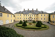
In the village, surrounded by Langerberg and Steinberg, lies the Hamberg with the Hamberg Chapel, which was built in 1923 in honor of the 34 fallen in the village in the First World War. There is also a grotto of Our Lady on the Hamberg, which was carved into the rock based on the model of the Lourdes grotto and was inaugurated on May 29, 1930 (Ascension Day). The landmark of Antfeld is the bright yellow Antfeld Castle .
coat of arms
Above a green shield base, diagonally divided from the right, on top of black silver sticks and iron, below on silver a black crutch cross, in the shield base a black eight-spoke wheel tire.
literature
- Hugo Cramer: The district of Brilon in the Second World War 1939–1945 - reports from many employees from all over the district. Josefs-Druckerei, Bigge 1955.
Web links
- Antfeld's website
- Antfeld in the Westphalia Culture Atlas
Individual evidence
- ^ City of Olsberg: Facts and Figures , accessed on July 7, 2018
- ^ Josef Rüther: History of the district of Brilon. Regensbergverlag, Münster 1957, p. 365.
- ↑ Bernd Schulte: From the archives of the Sauerland. Volume 1, Verlag Podszun, Brilon 1991, ISBN 3-923448-78-3 , pp. 32 and 33.
- ^ Hugo Cramer: The district of Brilon in the Second World War 1939-1945 . Section Antfeld, 1955, pp. 158-160.
- ^ Hugo Cramer: The district of Brilon in the Second World War 1939-1945 . 1955, honor roll section Antfeld, pp. 189–190.
- ^ Federal Statistical Office (ed.): Historical municipality directory for the Federal Republic of Germany. Name, border and key number changes in municipalities, counties and administrative districts from May 27, 1970 to December 31, 1982 . W. Kohlhammer, Stuttgart / Mainz 1983, ISBN 3-17-003263-1 , p. 332 .


