
Kahlenberg Castle (Lower Saxony)
| Kahlenberg Castle | ||
|---|---|---|
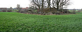
 Castle hill seen from the west, on the right the rising Harz mountains |
||
| Creation time : | 11th to 12th centuries | |
| Castle type : | Niederungsburg, moth | |
| Conservation status: | Burgstall, castle hill, rampart and moat | |
| Place: | Lutter am Barenberge - Rhode | |
| Geographical location | 51 ° 58 '6.2 " N , 10 ° 15' 10.8" E | |
|
||

The Castle Kahlenberg is a Outbound , small lowland castle in the district of Rhode the community Lutter am Barenberge in Lower Saxony . From the fortification in the construction of a medieval tower hill castle (Motte) only the castle hill as well as the moat and rampart remain. Structural remains have not been preserved.
Location and description
Kahlenberg Castle is located on the northwestern edge of the Harz in the Lutter basin . This area is part of the historical landscape of the Ambergau . In the narrower area, the castle site is in the lowland area of the Neile an der Gabel between the Steimker Bach, which runs in north-south direction, and the confluent Kiefbach. About 100 meters east and west of the castle hill are individual residential buildings and farms in the district of Rhode.
The castle hill was artificially piled up in marshy terrain. Today it lies on meadows and fields. It is a round hill with steep edges, which has a height of 5 meters and is lined with trees. The foot of the hill has a diameter of 22 meters. The flattened hilltop measures about 6 to 7 meters in diameter. On one side of the hill there is a demolition from the construction of a bunker in recent times, which no longer exists today. A moat about 10 meters wide ran around the castle hill , which is now silted up. A flat wall is in front of the ditch outside. Today it has a height of one meter and a width of 5 meters.
There is no documentary record of Kahlenberg Castle. Based on the structure and comparison with other castles of this type, it is assumed that it existed in the 11th and 12th centuries.
Investigations
In 1999 the University of Hanover carried out an excavation from July to November . It was found that the castle plateau originally had a diameter of about 12 meters and had recently been disturbed by excavations. A rectangular sandstone block was found, which probably served as the stone substructure for the wooden tower.
A second ditch was discovered during a 25-meter-long excavation cut in the vicinity of the castle hill, which led through the moat and the wall. It enclosed an area of land with traces of settlement. A settlement layer with charcoal, bricked clay, ceramics from the 12th and 13th centuries as well as metal parts and slag was found here. In addition, the remains of a building were found on the basis of post pits and slates of the roofing.

View from the south (2015)

The castle hill up close
View from the east with bumps from the moat and rampart


literature
- Friedrich Stolberg: Kahlenberg near Rhode , in: Fortifications in and on the Harz from early history to modern times , Hildesheim 1968, p. 198
- Georg Schlicksbier, Rüdiger Schulz, Andreas Bingener : Rhode - a center of medieval non-ferrous metal smelting on the northwestern edge of the Harz? in: Reports on the preservation of monuments in Lower Saxony 2/99, pp. 62–66.
Web links
- Entry by Stefan Eismann about Kahlenberg Castle in the scientific database " EBIDAT " of the European Castle Institute
- Brief report on excavations at Kahlenberg Castle in 1999
- Photographic reconstruction of the tower hill castle
- Mention of the castle site as a station on a hiking trail around Lutter am Barenberge (pdf)
- Listing at burgdaten.de
- Entry on Kahlenberg Castle in the private database "Alle Burgen". Retrieved December 15, 2015.