Mühlbach Castle

The castle Mühlbach was 0.8 kilometers north of the castle Kürnberg and 0.7 km south-east of the farm Hackl on the mountain in the district Rufling the municipality of Leonding in District Linz-Land of Upper Austria .
history
Mühlbach Castle is identical to a weir system discovered in 1910 in the so-called Steyregger Forest on the Kürnberg-Westhang (the earthwork was referred to as "Sperrfeste F"). also known as "Edge fortification Wagner am Berg").
In 1159, on the occasion of property swap negotiations, a Konrad von Mühlbach and his brother Walter were named as Passauer Ministeriale . In a certificate from Abbot Gebhard II von Wilhering , Konrad is listed again as Passau Ministeriale. The Wilheringer Stiftsbuch from 1244 to 1254/57 again mentions Konrad as Ministeriale of Wilhering-Waxenberg , possibly there was a double employment relationship. Specifically, Dominus Konrad von Mühlbach and his castle appear in the boundary description on the occasion of an exchange of land (between the Wilhering monastery and pastor Pilgrim von Schönering) . The barter agreement between Konrad von Mühlbach and the monastery between 1189 and 1201 shows that Konrad exchanged his goods in Mühlbach and Kürnberg for property in Durinstetin . After the bartering was completed, Konrad appeared among the parishioners of Gramastetten around 1206 . His line then probably built the small castle Mühlberg, which is mentioned in a document in 1270 with Dietmar von Mühlberg.
The end of Castle Mühlbach am Kürnberg lies in the darkness of history; It is most likely that the fortress was abandoned after the land swap around 1200.
Mühlbach Castle today
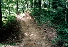
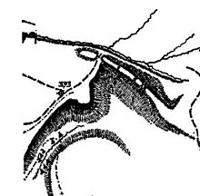
Mühlbach Castle is located on a striking knock-back hill above the valley gorge of the Mühlbach, which is referred to here as the Steyregger Graben. The castle is now preserved as a section fortification on a slope spur. The size of the core plant is approx. 50 × 15 m. In the southeast there is a mighty, double moat; in the north-west a simple moat; There is a step on the slope around the earthworks. The broad crown of the inner wall suggests a tower that once stood on it.
The finds come from the Bronze Age and the High Middle Ages . It can therefore be assumed that the strategically important place was already settled or fortified in the Bronze Age.
The facility is damaged by a recent forest road.
literature
- Christian K. Steingruber : Research area Kürnberg: New knowledge about prehistoric and early historical soil monuments. In: Upper Austrian homeland sheets . Issue 3/4, volume 61, Linz 2007.
- Christian K. Steingruber: Prehistoric and early historical monuments on the Kürnberg near Wilhering. In: Marktgemeinde Wilhering (Hrsg.): Wilhering. Volume 1, compiled by H. Heisler with numerous photo contributions by Anton S. Kehrer. Denkmayr, 2006.
- Christian K. Steingruber: A critical consideration of the historical-topographical manual of the fortifications and mansions of Upper Austria . Upper Austrian Provincial Archives , Linz 2013.
- Alois Zauner : The beginnings of the Wilhering Zisterze. In: Mitteilungen des Oö. State Archives. Volume 13, Linz 1981 ( online (PDF; 6.9 MB) in the forum OoeGeschichte.at).
Individual evidence
- ↑ Steingruber, 2013, p. 212.
