
Burgess Hill
| Burgess Hill | |||
|---|---|---|---|
 |
|||
| Coordinates | 50 ° 57 ′ N , 0 ° 8 ′ W | ||
| OS National Grid | TQ317187 | ||
|
|||
| Residents | 28,803 (as of 2001) | ||
| surface | 9.47 km² (3.66 mi² ) | ||
| Population density: | 3041 inhabitants per km² | ||
| administration | |||
| Post town | BURGESS HILL | ||
| ZIP code section | RH15 | ||
| prefix | 01444 | ||
| Part of the country | England | ||
| region | South East England | ||
| Shire county | West Sussex | ||
| District | Mid Sussex | ||
| Website: www.burgesshill.gov.uk | |||

Burgess Hill is a town in the district of Mid Sussex in the county of West Sussex in England . 28,803 inhabitants live in Burgess Hill (as of 2001). The city belongs to the group of Fairtrade Towns .
location
The city is 62 kilometers south of London and 16 kilometers north of Brighton . Nearby is the South Downs National Park , which officially opened in 2011.
history
The name Burgess Hill probably goes back to a family called "Burgeys". The name appears in the tax lists at the end of the 13th century. Between 1850 and 1880 the insignificant rural settlement grew into a town with 4500 inhabitants. The city experienced the greatest increase in population between the years 1951 and 1961. During this time the population doubled.
religion
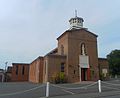
There are a total of twelve churches and sacred buildings in the city, three of which belong to the Church of England and the other nine serve different denominations, including Baptists , Methodists , Pentecostals , the Roman Catholic Church , the Salvation Army and Jehovah's Witnesses .

St. John the Evangelist Anglican Church
Catholic Church of
St. Wilfrid
Burgess Hill Methodist Church


Town twinning
Burgess Hill has twinned cities with the French Abbeville and the German city of Schmallenberg .