
Burghsluis
| province |
|
| local community |
|
| Residents | 80 |
| Coordinates | 51 ° 41 ′ N , 3 ° 45 ′ E |
| prefix | 0111 |
| Postcodes | 4328, 4675 |
 |
|
Burghsluis is a village on the north bank of the Oosterschelde in Schouwen-Duiveland in the Dutch province of Zeeland .
The place has had a small, initially mainly agricultural port on the Oosterschelde since the 15th century , which is now mainly used for recreational shipping , but was formerly also used for fishing and as a works port of the Rijkswaterstaat . Since the port was in the area of the municipality of Haamstede , the fishing boats were marked HS . Around 1865, the port was fortified and enlarged and after the flood disaster of 1953 , which also caused great damage and killed in Burghsluis and the neighboring towns of Serooskerke and De Schelphoek, it was deepened again during the construction of the nearby Delta Works and expanded to around four hectares.
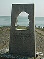
From 1862 until the destruction by the German occupation in 1945 there was a station of the Koninklijke Nederlandse Redding Maatschappij (KZHMRS) in Burghsluis to rescue shipwrecked people. The “Rescuers of Schouwen-Duiveland” ( “Voor de Redders op Schouwen-Duiveland” ) was erected in 1989 by Miens van Citters from Burgh at the harbor.
The dome-shaped house at the harbor is the former dome of the Westerlichttoren lighthouse in Nieuw Haamstede, the upper part of which was replaced in 1981. It serves as the harbor master's office.
About two kilometers northeast of Burghsluis is the late Gothic tower Plompetoren in the village of Koudekerke, which was sunken in the 15th century.
photos
Sea Rescuer Memorial

Plompetors


Web links
- Website with information (Dutch)
- Burghsluis: Website of the tourist association VVV Zeeland (German, Dutch, English)