
Burgh-Haamstede
| province |
|
| local community |
|
|
Area - land - water |
37.35 km 2 37.17 km 2 0.18 km 2 |
| Residents | 4,230 (Jan 1, 2017) |
| Coordinates | 51 ° 42 ′ N , 3 ° 45 ′ E |
| Important traffic route |
|
| prefix | 0111 |
| Postcodes | 4325-4328 |
| Website | Homepage of Burgh-Haamstede |
 |
|

Burgh-Haamstede is a village in the municipality of Schouwen-Duiveland in the Dutch province of Zeeland . It consists of the villages of Burgh and Haamstede, each with its own village center and church. In the meantime, however, the two villages form a unit. Burgh-Haamstede has 4,230 inhabitants.
A settlement of the Vlaardingen culture with two-aisled houses was found near Haamstede between old beach walls .
The Zeeland coastal marathon, which takes place every year on the first weekend in October, starts in Burgh-Haamstede and ends in Zoutelande .
Attractions
Burgh was founded in the 9th century AD as a ring wall . The ring shape can still be seen.
In Haamstede there is Slot Haamstede , a castle with a defense tower from the 13th century AD, and the attached Slotbos , a park-like forest area.
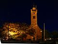
In the center of the village is the late Gothic Protestant St. John's Church .
The Westerlichttoren lighthouse has stood in the north-west of Nieuw-Haamstede since 1837 .
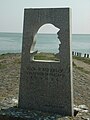
The small port town of Burghsluis is located southeast of Burgh-Haamstede on the Oosterschelde . A station of the Royal Society for the Rescue of Drowning with a lifeboat stood there since 1862 (until it was destroyed by the German occupiers in 1945) . A memorial to the sea rescuers of Schouwen-Duiveland was unveiled here in 1989. During the flood disaster of 1953 , Burghsluis and the neighboring towns of Serooskerke and De Schelphoek were badly affected, and there were also fatalities.
About two kilometers northeast of Burghsluis (in the direction of Zierikzee ) stands the Plompe Toren directly on the dike , the last remnant of the village of Koudekerke, which sank in the Oosterschelde. There is also a suitable place for scuba divers.
photos

Haamstede, Evangelical St. John's Church
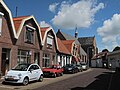
Haamstede, street with church
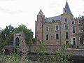
Haamstede, castle
Burghsluis, sea rescue memorial

Bakkerij Sonnemans in Burgh

Bulky tower

Pancake mill with art park
Reformed Church in Burgh


Web links
- Website of the place (including Dutch, German, English, French)
- Tourist office website (Dutch)
- Burgh-Haamstede: Website of the tourist office VVV Zeeland (German, Dutch, English)
- Plompe Toren website (Dutch)
Individual evidence
- ↑ a b Kerncijfers wijken en buurten 2017 Centraal Bureau voor de Statistiek , accessed on April 9, 2018 (Dutch)
- ↑ Description of the dive site , Dutch, accessed January 18, 2016
Brouwershaven | Bruinisse | Three choir | Ellemeet | Haamstede | Kerkwerve | Nieuwerkerk | Noordgouwe | Noordwelle | Oosterland | Ouwerkerk | Renesse | Scharendijke | Serooskerke | Zierikzee | Zonnemaire