Three choir
 flag |
 coat of arms |
| province |
|
| local community |
|
|
Area - land - water |
15.59 km 2 15.15 km 2 0.44 km 2 |
| Residents | 995 (Jan. 1, 2017) |
| Coordinates | 51 ° 41 ′ N , 3 ° 59 ′ E |
| height | 1 m NAP |
| prefix | 0111 |
| Postcodes | 4306, 4308, 4315-4317 |
| Website | Homepage of Dreischor |
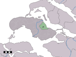
| Location of Dreischor in the municipality of Schouwen-Duiveland | |
Dreischor ( Zeeland Dreister ) on Schouwen-Duiveland is one of the best preserved of the 15 ring villages (Ringdorp, also called Kerkringdorp - Kirchenringdorf) in the Dutch province of Zeeland . The village has 995 inhabitants (as of January 1, 2017). The village view is under monument protection.
The oldest mention of the place comes from the year 1206. During its heyday Dreischor was the center of the flax industry and cultivation area for red dye . The nearby hamlet of Beldert served Dreischor as a port.
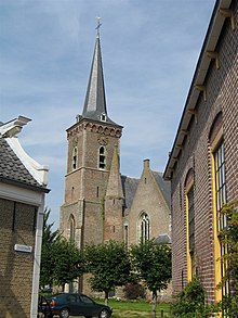
In the middle of the village is the two-aisled, restored Sint Adrianus Church , which has one of the most beautiful burial chapels in the Netherlands. Its tower sank while it was being built, in the 15th century. The builders corrected this, but the tower still looks a bit crooked today. There are historical buildings on the ring. The former town hall with its stepped gable dates from 1637. A shoeing or forced status, for shoeing horses, stands in front of the former blacksmith's shop.
For 150 years, the Dreischor polder was a small island formed by the Sonnemare and the Gouwe River, which separated Schouwen and Duiveland. Dreischor was only connected to Schouwen through poldering.
In the Middle Ages, Dreischor was given the right to hold a horse market in nearby Beldert. The inhabitants were obliged to ship their agricultural products from here. Since Beldert was on the Dijkwater, which had a direct connection to Grevelingen , a shipping line to Rotterdam was set up. The flood disaster of 1953 put an end to everything. The young vineyards of Schouwen-Duiveland are located near Beldert today.
Until the Agathen flood in 1288, Dreischor and Sirjansland were on the same polder . The new connection with Sirjansland on Duiveland was only established after the flood disaster of 1953 when the Dijkwater was diked and turned into a unique nature reserve. On the Molenweg, in the direction of Sirjansland, lies the "bricked ground sailor" Aeolus, a restored mill.
Web links
- Place website (Dutch)
- Dreischor: Website of the tourist association VVV Zeeland (German, Dutch, English)
Individual evidence
- ↑ a b Kerncijfers wijken en buurten 2017 Centraal Bureau voor de Statistiek , accessed on April 8, 2018 (Dutch)

