
Kronest castle ruins
| Kronest castle ruins | ||
|---|---|---|
 Kronest castle ruins |
||
| Alternative name (s): | Bibrachstein ruins | |
| Creation time : | 1334 | |
| Castle type : | Hilltop castle | |
| Conservation status: | ruin | |
| Place: | Neumarkt in the Mühlkreis | |
| Geographical location | 48 ° 26 '53 " N , 14 ° 28' 58" E | |
| Height: | 600 m above sea level A. | |
|
||

The castle ruin Kronest (also: Bibrachstein ) is the ruin of a hilltop castle at 600 m above sea level. A. about two kilometers north of Neumarkt in the Mühlviertel in Upper Austria . Kronest Castle was mentioned for the first time in a document around 1334, and it was no longer inhabited by 1609.
history
The first documentary mention comes from the year 1334, when the district judge of the Machland zu Freistadt , Friedrich Schrautolf, received permission from the sovereign to build a castle on this site. Since the land belonged to St. Florian Monastery, he had to pay ten pfennigs tax to the monastery every year. In addition, he had to hand over a farm as compensation. In 1377 Hans der Lasberger bought the castle ( Chranest ) and also paid the tax to the monastery. The name at that time was the tower of the Schrautolf , which indicates a former residential tower ( turris Schrautolfi ). In the course of the Hussite Wars , the castle was affected, the defense tower burned down around 1428. The current name Kronest, which means crow's nest, came up around this time.
Around 1455 a Caspar von Alharting was named as the owner. In 1508 the castle was a princely fief . Veit von Zelking sold half of the castle to the Piberhof in 1527 and united the castle with the rule of Weinberg . In the same year the castle was sold to the Thürheimer family , who acquired the Weinberg Castle after the Counter Reformation. The Thürheimers called the castle Bibrachstein , named after the castle "Bibrachzell" (today "Biberachzell", a district of Weißenhorn in the district of Neu-Ulm in Bavarian Swabia), one of their ancestral castles. The latter designation could not prevail.
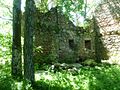
Kronest was probably destroyed and burned out in the Hussite Wars . The reddish discoloration on the inside indicates that the fixed seat was destroyed by a fire explosion. The last documentary mention comes from 1602, Kronest is referred to as Ödes Stöckl . Since then, the castle has deteriorated and is now just a ruin.
Kronest today
The building is located on a low rocky hill near the village of Kronast. The ruins cannot be seen from the road in Kronast, as the castle hill is now completely overgrown by trees and bushes. If you walk south from the tennis court towards the small hill, you come across the walls.
Three outer walls of the castle are still visible today, the east wall, the former entrance, has completely disappeared. The castle was more of a residential complex than a fortification. Only the entrance was five meters high to protect yourself. The castle could not withstand a siege, hence the partial destruction during the Hussite Wars. The castle had a square base of 144 square meters with walls 12 meters long. The wall thickness on the ground floor was one meter thick, on the first floor around 80 centimeters. Local farmers used stones for their houses and thus contributed to the demolition of the castle.
The beam holes that are still visible show the former two floors including the attic. In the past, a corridor from the cellar of the castle is said to have led into the forest to an underground well. In addition to the water supply, this corridor served as an escape route.
photos

Kronest castle ruins: outer wall
Kronest Brugruine: southern wall

Kronest Castle: outer wall

Kronest Castle: western inner wall

Kronest Castle: Overgrown castle hill


literature
- Norbert Grabherr : Castles and palaces in Upper Austria. A guide for castle hikers and friends of home. 3rd edition . Oberösterreichischer Landesverlag, Linz 1976, ISBN 3-85214-157-5 .
- Oskar Hille: Castles and Palaces of Upper Austria , Wilhelm Ennsthaler, Steyr, 2nd edition 1992, ISBN 3850683230
Web links
- Kronast on Burgenkunde.at
- Entry over Kronest castle ruins on Burgen-Austria