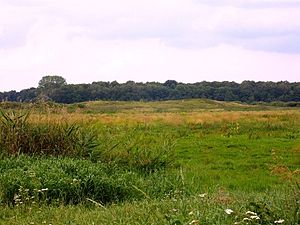
Mölln castle wall
| Mölln castle wall | |
|---|---|
|
Castle ramparts in summer |
|
| Alternative name (s): | Seeberg |
| Creation time : | 10th to 12th centuries |
| Castle type : | Niederungsburg |
| Conservation status: | Wall remains |
| Place: | Mölln |
| Geographical location | 53 ° 35 '48 " N , 13 ° 5' 3" E |
The Mölln castle wall is located north of Mölln in the Mecklenburg Lake District on the edge of the almost silted-up Möllner See . The Slavic rampart is a former island castle . The ramparts have been almost leveled through arable farming, but the castle ramparts can still be seen in the area. Excavations by Volker Schmidt in 1988 revealed the location of a possible Tollenser prince here . The complex was two-part, oval and had only one entrance gate. An arched bridge led from Mölln to the former Burgwallinsel. The bridge was built on an artificial sand dam, which can still be seen today in times of less vegetation. Accordingly, the lake was very low in terms of water level as early as the 10th to 12th centuries. As far as we know today, Möllner Castle was the traditional Gotebant Castle . As massive layers of charcoal were found during the investigations, the Inselburg is likely to have perished in a major fire disaster. Today the castle lies on the Möllner See, which was still connected to the Gädebehner See and Kastorfer See during the Slav period . Since there were several other Slavic castles on this larger body of water, it can be assumed that the lake must have had a certain importance during the Slav period. It is believed that the Tollensians were the center of political and economic power here.
literature
- Georg Christian Friedrich Lisch : The castle and the land of Gotebant. In: Yearbooks of the Association for Mecklenburg History and Archeology. - Vol. 25 (1860), pp. 268–278 ( digitized version )
- Volker Schmidt : Slavic ramparts on the Kastorfer-Möllner chain of lakes . In: Alfried Wieczorek , Hans-Martin Hinz (Hrsg.): Europes Mitte um 1000. Theiss, Stuttgart 2000, ISBN 3-8062-1544-8 , pages 282–285.
