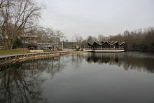
Buschmühle (Dortmund)
The Buschmühle was an estate with a mill on the Emscher and until the Second World War a well-known excursion restaurant in the south of the city of Dortmund . The name is now given to a restaurant in Westfalenpark , which is located on the site of the old Buschmühle.
history
Probably the first documentary mention of the Buschmühle is in a protocol of the city council, which in 1378 leased the Emscherstau to the citizen Tidemann von Palstod with the permission to build a mill house there. The mill later came into the possession of the Counts of Dortmund and was destroyed by troops from the Brandenburg region in 1446 . When the last of the Dortmund counts from the Lindenhorst family died in 1453, his widow Marie von Lindenhorst pledged the mill to Andreas Klepping, later it fell to the city council and was consequently referred to as the "council mill". In 1661 the mill was called "Hövelsche Mühle", and in 1691 finally "Busch-Mühle". In the 18th century, the manor again changed hands several times, in 1723 it was Beurhaus, in 1727 Löbbecke, after which the hall was called "Löbeken Busch" and the mill was called "Löbeken Mühle". At the end of the 18th century, the mill finally came into the possession of the Romberg family .
Since day trippers often visited the Mühlenhof and had a snack there, the pension administration of Freiherr zu Romberg built a restaurant with a ballroom for over 300 guests northeast of the estate , which was opened in 1894 when the nearby Kaiser Wilhelm grove was opened. While the previous tenant of the estate, Johann Wortberg, continued to manage it, the new restaurant was leased to the Germania brewery from Münster. In an advertisement at the time, the restaurant was advertised as a “first-class establishment”, emphasizing the easy accessibility with the Dortmund – Hörde electric tram and the electric lighting. However, the latter was not registered with the city of Dortmund until July 15, 1895 (after a trial period): The ever-decreasing importance of the water-powered grain mill made it possible to stop the mill and instead generate electricity by means of a turbine on the mill. In addition to the restaurant, the adjoining park and the mill pond could be illuminated, which led more visitors to the Buschmühle. In 1898 the building of the hall was expanded to include a farm building and a larger veranda, and in the following years the restaurant “Zur Buschmühle” developed beyond the city limits into a well-known excursion restaurant.
On July 31, 1926, the city of Dortmund bought the Romberg property and with it the Mühlenhof and the restaurant. In 1942, the Dortmund architect Adolf Ott suggested rebuilding the entire Buschmühlen site and using the old mill as the focal point to create a “simple, beautiful and contemporary recreation area”, which however could no longer be realized due to the war. During air raids on the city of Dortmund on the night of May 23, 1944, the buildings of the manor and the restaurant were destroyed.
The bush mill today
The field name remained despite the destruction and can be found today, for example, in the street name “An der Buschmühle”. An allotment garden was built on the site of the former estate , the Buschmühlenteich and the destroyed restaurant building became part of the newly opened Westfalenpark in 1959 , which also uses the Buschmühlenpark site. For the 1991 Federal Garden Show, the remains of the former restaurant were removed and a new restaurant was built in its place, which was given the traditional name “Zur Buschmühle”. In memory of the eponymous mill, a mill wheel was built next to the restaurant .
Individual reference / source
- ^ A b Oskar Jünger in his home town of Dortmund; City history in pictures and reports. Journal of the historical association for Dortmund and the Grafschaft Mark eV, issue 09/1988
Web links
- On the history of the Buschmühle ( Memento from June 14, 2016 in the Internet Archive )
- Garden Association Buschmühle
Coordinates: 51 ° 29 ′ 32.4 " N , 7 ° 28 ′ 49.5" E


