
Byrd glacier
| Byrd glacier | ||
|---|---|---|
 Satellite photo |
||
| location | East Antarctica | |
| Mountains | Transantarctic Mountains | |
| length | 135 km | |
| width | ⌀ 24 km | |
| Coordinates | 80 ° 20 ′ S , 159 ° 0 ′ E | |
|
||
| drainage | Ross Ice Shelf | |

The Byrd Glacier is a glacier located in East Antarctica . The approximately 135 km long and 24 km wide glacier flows in an easterly direction between the Britannia Range and the Churchill Mountains , to flow into the Ross Ice Shelf at Barne Inlet . The glacier was named after the American polar explorer and Admiral Richard Evelyn Byrd .
With a typical outlet volume of 20 km³ and an outlet speed of 825 m per year, it is one of the largest outlet glaciers in Antarctica. In 2006, a river flowing under the glacier increased the speed by 10% and increased the outlet volume to 22 km³ per year.
Topographic map sheets
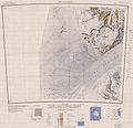
Western part

Eastern part


Web links
Commons : Byrd Glacier - Collection of Images, Videos and Audio Files
Individual evidence
- ^ "Byrd Glacier". United States Geological Survey , Geographic Names Information System , January 7, 2010, accessed January 7, 2010 .
- ^ Leigh A. Stearns , Benjamin E. Smith , Gordon S. Hamilton : Increased flow speed on a large East Antarctic outlet glacier caused by subglacial floods. Nature , November 16, 2008, accessed November 14, 2009 .
- ↑ Jonathan Amos : "Under-ice flood speeds up glacier". BBC News , November 17, 2008, accessed November 14, 2009 .