Byskeälven
| Byskeälven | ||
|
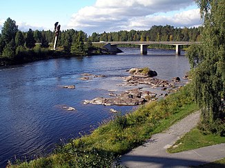
Byskeälven under the European route 4 near Byske |
||
| Data | ||
| location | Norrbottens län , Västerbottens län ( Sweden ) | |
| River system | Byskeälven | |
| origin | Lake Västra Kikkejaure near Arvidsjaur 65 ° 39 ′ 0 ″ N , 19 ° 7 ′ 4 ″ E |
|
| Source height | 366 m above sea level | |
| muzzle | at Byske in the Gulf of Bothnia coordinates: 64 ° 56 ′ 33 ″ N , 21 ° 14 ′ 0 ″ E 64 ° 56 ′ 33 ″ N , 21 ° 14 ′ 0 ″ E |
|
| Mouth height | 0 m o.h. | |
| Height difference | 366 m | |
| Bottom slope | 1.7 ‰ | |
| length | 215 km (including source rivers) | |
| Catchment area | 3,661.8 km² | |
| Drain |
MQ |
40 m³ / s |
| Right tributaries | Långträskälven | |
| Flowing lakes | Arvidsjaursjön | |
| Communities | Arvidsjaur , Byske , Fällfors | |
Byskeälven is a Swedish river about 215 kilometers long , which has its source in the lake area near Arvidsjaur .
The source of the Byskeälven is the Järferälven . At Arvidsjaur it flows through the lake Arvidsjaursjön . The Byskeälven and its tributaries are subject to strong seasonal fluctuations in terms of the amount of water. On its way the river flows through the provinces of Norrbottens län and Västerbottens län .
The river is known for its abundance of salmon . A salmon fishing center has been set up near the rapids in Fällfors , about 30 kilometers from the mouth of the river in the Gulf of Bothnia . Among other things, there is a glass wall here that allows a side view of the river.
Web links
Individual evidence
- ↑ SMHI - Sjöareal och sjöhöjd (PDF; 3.5 MB)
- ↑ Sveriges Meteorologiska och Hydrologiska Institut (SMHI) - Län och huvudavrinningsområden i Sverige (PDF; 2.5 MB)
