Cala des Camps
| Cala des Camps beach | ||
|---|---|---|
| location | Artà municipality | |
| Geographical location | 39 ° 44 ′ 53 " N , 3 ° 18 ′ 4" E | |
|
|
||
| length | 100 m | |
| width | 10 m | |
| nature | Pebbles and stones | |
| water | Seagrass deposits are common | |
| Surroundings | little developed | |
| tourism | ||
| Visitor frequency | little visited | |
| Parking spaces | on the street | |
| monitoring | no | |
| Nudism | Yes | |
| next hospital | Hospital de Manacor (15.4 miles) | |
| next port | Colonia de Sant Pere (4.4 km) | |
| Beaches and bays in Mallorca | ||
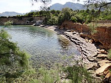
Cala des Camps (also Caló des Cans , Caló Camps , Calo's Cans or Ca los Camps ) is a small bay with a narrow sandy beach in the northeast of the Balearic island of Mallorca . It is located seven kilometers northwest of the small town of Artà .
Location and description
The Cala des Camps is located on the north coast of Mallorca on the Badia d'Alcúdia ('Bay of Alcúdia ') between the town of Colonia de Sant Pere in the southwest and the settlement (Urbanització) Betlem in the northeast. The bay is part of the municipality of Artà. On the northeast side of Cala des Camps, the torrent Torrent des Cocons (also Torrent de Betlem ) flows into the Mediterranean , which rises in the mountains of Artà, part of the Serres de Llevant , at the Font de s'Ermita not far from the Ermita de Betlem . Although the spring is constantly providing water, the torrent only carries water when it is used for irrigation on its lower reaches during heavy rainfall and otherwise falls dry.
The bay of es Camps extends about 200 meters inland and is about 170 meters wide at its sea-side entrance. The sea inlet is flanked on both sides by a cliff of low altitude with rocks. On the southeast side is the beach surrounded by tamarisk and pine trees , which is mostly covered with seagrass deposits . Around the mouth of the Torrent des Cocons the cliff is interrupted and the beach reaches its greatest width. North of the estuary, four Escars , shelters for small fishing boats, the Llaüts , are built on the bank rocks. Between them is a machine gun stand from the Spanish Civil War . Although the beach of Cala des Camps is rarely visited, it is very limited in area.
Access
From Colonia de Sant Pere a road leads directly on the coast via Son Violí and Son Mascaró in a north-easterly direction to Cala des Camps, where the road ends. About halfway there is a connection road to the MA-3331, the main road from Betlem into the interior of the island. Since August 2020, only residents of the Artà community have been allowed to park their vehicles at the last 700 meters to the bay. The settlement of Betlem, located in the northeast of Cala des Camps, is connected to the bay by a hiking trail.
literature
- Bartomeu Amengual Gomila: Mallorca's coasts from the air . Detailed and practical travel guide with aerial photos of Mallorca's coasts. 6th edition. Editorial GeoPlaneta, Barcelona 2000, ISBN 84-08-01821-3 , Ca los Camps - Ermita de Betlem, p. 104 (Spanish, original title: Aeroguía del litoral de Mallorca . Translated by Gabriele Grauwinkel and Susanne Pospiech).
- Miguel Ángel Álvarez Alperi: Comprehensive Beach Guide Mallorca + Cabrera . 1st edition. Ediciones El Cohete, Gijón 2001, ISBN 84-87933-08-4 , Platja Calo's Cans, p. 170/171 .
- Belén Menéndez Solar: Guide de Playas de Mallorca . 1st edition. Ediciones El Cohete, Gijón 2008, ISBN 978-84-87933-11-0 , Caló Camps, p. 131 (Spanish).


