Calderón Hondo
| Calderón Hondo | ||
|---|---|---|
|
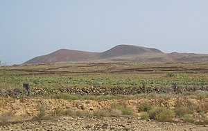
View from the southwest |
||
| height | 278 m | |
| location | Fuerteventura, Spain | |
| Coordinates | 28 ° 42 ′ 0 ″ N , 13 ° 55 ′ 13 ″ W | |
|
|
||
| Type | Cinder cone | |
| rock | basalt | |
| Last eruption | 15,000 to 30,000 years ago | |
The Calderon Hondo is a volcano on to Spain belonging Canary Island Fuerteventura in the Atlantic Ocean .
Location and surroundings
The Calderón Hondo is located on the northern end of the island of Fuerteventura in the Atlantic Ocean. It belongs to the Volcanes de Bayuyo , which form a series of cinder volcanoes oriented from southwest to northeast over a fault line in the earth's crust . The distance from the Calderón Hondo to the coast is about five kilometers.
Heights
The highest point on the crater rim reaches a height of 278 m , according to other sources 277 m . The deepest point in the crater is at 162 m . The crater rim has a height of 227 m at the lowest point . This results in a depth of the crater of at least 66 meters.
Approach to the crater rim
An unpaved road branches off the road to Majanicho north of the village of Lajares . This road ends after about two kilometers. From here the local hiking trail SL FV 2 begins, which leads a little around the mountain to the edge of the crater.
Others
At the edge of the crater there is a small viewing platform with a railing. In the crater, near the crater rim, yellowish sulfur deposits can be seen.
Web links
Individual evidence
- ↑ LA Cueto Pascual, R. Balcells Herrera, JL Barrera Morate: Mapa geológico de España . Scale 1: 25,000, sheet 1086 I / 1087 I – IV: Isla de Fuerteventura. Tostón-Corralejo . Instituto Geológico y Minero de España, Madrid 1990, ISBN 84-7840-501-1 , S 24. Accompanying booklet (PDF; 912 kB), accessed on April 5, 2018 (Spanish).
- ↑ KOMPASS hiking, biking, leisure and road map No. 240 Fuerteventura , KOMPASS-Karten GmbH, Rum / Innsbruck
- ^ ADAC map Canary Islands , 1999, ADAC Verlag Munich
- ↑ Information on the local hiking trail SL FV 2: Calderón Hondo - Lajares on the website of the Spanish Ministry of Agriculture, Food and Environment, accessed on April 5, 2018

