
Volcanes de Bayuyo
| Volcanes de Bayuyo | ||
|---|---|---|
 View over Corralejo to the volcanoes |
||
| Highest peak | Calderón Hondo ( 278 m ) | |
| location | Fuerteventura | |
|
||
| Coordinates | 28 ° 42 '38 " N , 13 ° 54' 7" W | |
| rock | basalt | |

The Volcanes de Bayuyo form a series of volcanoes in the municipality of La Oliva on the Canary Island of Fuerteventura .
description
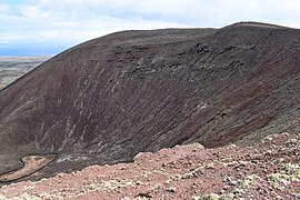
The volcanoes stand along a fault line running from southwest to northeast between Lajares and Corralejo . Their cinder cones reach heights between 200 and 270 meters.
The series begins northeast of Lajares with the crescent-shaped Montaña Colorada , which is composed of the remains of two volcanic cones and rises almost 150 m above the surrounding area to a total height of 248 m. The mountain owes its name to its intense red-brown color. It is connected to the Calderón Hondo via a 214 m high saddle, which is the highest point in the volcanic series at 278 m. The bottom of its round, 350 m × 300 m wide crater has a height of 162 m and is 66 m below the deepest point of the crater rim. Across a depression is the horseshoe-shaped Caldera Rebanada , which opens to the northwest and is closely connected to the volcanic building of the Caldera Encantada , which opens to the east. The common crater wall reaches a height of 253 m. The Las Calderas volcanic cone joins to the northeast . Its crater, the wall of which is over 120 m higher in the west than in the east, has a diameter of 500 m. A saddle only 137 m high leads over to the nestling volcanic buildings of Bayuyo and Montaña San Rafael . The Bayuyo rises about 170 m over the surrounding area at a height of 271 m. Its 500 m wide crater opens in a horseshoe shape to the northwest, while the Montaña San Rafael is oriented to the northeast. The series of volcanoes has an extension of 4.5 km between Montaña Colorada and Montaña San Rafael .

Montaña Colorada from the southwest

View into the crater of Calderón Hondo

View from Bayuyo to the Las Calderas crater

Bayuyo summit
View into the Bayuyo crater


Emergence
The fourth and most recent eruptive phase of the geological history of Fuerteventura began around 50,000 years ago, during which the Volcanes de Bayuyo came into being, which is sometimes dated 15,000 to 30,000, sometimes 30,000 to 50,000 years in the past. Until then, the north coast of the island was on the line from El Cotillo via Lajares to El Guriame. Through the eruptions and lava flows of the Volcanes de Bayuyo and the volcanic group of Montaña de la Mancha , Montaña de la Raya and Montaña de Lomo Blanco , which is 2.5 km northwest of the Volcanes de Bayuyo on another fault line also oriented from southwest to northeast, led to the formation of the Malpaís de Corralejo and enlarged the island area by 110 km². The total volume emitted is estimated at just under one cubic kilometer. At the same time as the Volcanes de Bayuyo, the island of Lobos with its volcano Montaña La Caldera was formed on the same fault line in the earth's crust .
environment
The Volcanes de Bayuyo enjoy no state protection. Three of the seven volcanoes are visibly affected by quarries used to mine Picón .
As everywhere on Fuerteventura, the flora and fauna are poor in species. Several species from the foxtail family grow in the area, such as the worm-shaped saltwort ( Salsola vermiculata ), the Suaeda vera and Chenoleoides tomentosa . Often one finds the knotted ice plant ( Mesembryanthemum nodiflorum ), occasionally the oleander-leaved small tree ( Kleinia neriifolia ). Among the animals, the birds are particularly noteworthy. The canary slacker ( Saxicola dacotiae ), which is represented by several pairs, occurs worldwide only on Fuerteventura. There are also common ravens ( Corvus corax ) and stump larks ( Calandrella rufescens ) as well as a larger population of the desert bullfinch ( Bucanetes githagineus ). Occasionally birds of prey such as the common buzzard ( Buteo buteo insularum ) and the Canary barn owl ( Tyto alba gracilirostris ) are sighted. The atlas squirrel ( Atlantoxerus getulus ), which was introduced from North Africa in the 1960s and is often used to and trusting with people, is also common.
tourism

The second stage of the main hiking trail Fuerteventura GR 131 leads from Corralejo to La Oliva along the northwestern edge of the Volcanes de Bayuyo and on through the valley between Calderón Hondo and Caldera Rebanada . A variant of the route via the Montaña San Rafael and the Bayuyo rewards with views of the entire north of Fuerteventura and the neighboring islands of Lobos and Lanzarote .
The local hiking trail SL FV 2 leads from Lajares to the viewing platform on the crater rim of Calderón Hondo and to an abandoned homestead in the wasteland.
literature
- LA Cueto Pascual, R. Balcells Herrera, JL Barrera Morate: Mapa geológico de España . Scale 1: 25,000, sheet 1086 I / 1087 I – IV: Isla de Fuerteventura. Tostón-Corralejo . Instituto Geológico y Minero de España, Madrid 1990, ISBN 84-7840-501-1 . Booklet (PDF; 912 kB), accessed on April 5, 2018 (Spanish).
Web links
Individual evidence
- ↑ a b L. A. Cueto Pascual et al .: Booklet to the Mapa geológico de España , 1990, p. 24
- ↑ a b Juan Miguel Torres Cabrera, Patricia Lillo Puig: Guía de campo del Malpaís de la Arena y su entorno (PDF; 25.8 MB). Cabildo Insular de Fuerteventura, 1996, ISBN 978-84-87461-43-9
- ↑ Inventario de recursos vulcanológicos de Fuerteventura. Consejería de Turismo del Cabildo de Fuerteventura, 2011, p. 48, accessed on April 5, 2018 (Spanish).
- ^ Hiking sign in Lajares, as seen on February 25, 2018.
- ↑ Hiking sign on Morro Francisco, as seen on February 25, 2018.
- ↑ Information on the 2nd stage of the GR 131: Corralejo - La Oliva hiking trail on the website of the Spanish Ministry of Agriculture, Food and Environment, accessed on April 5, 2018
- ↑ Information on the local hiking trail SL FV 2: Calderón Hondo - Lajares on the website of the Spanish Ministry of Agriculture, Food and Environment, accessed on April 5, 2018