California State Route 3

|
|
|---|---|
| map | |

|
|
| Basic data | |
| Overall length: | 235.5 km (146.3 miles ) |
| Starting point: |
|
| End point: | Montague |
| Counties: |
Trinity Siskiyou |
The California State Route 3 (short- CA 3 ) is about 235 km long state highway in the north of the US -Bundesstaat California , which runs north-south direction.
course
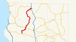
CA 3 begins in Trinity County at Peanut on California State Route 36 . From here it runs first north, then northeast, crosses California State Route 299 and passes, among other things, Trinity Lake . The road follows the Trinity River and later the Scott River further north until it turns northeast and crosses Interstate 5 at Yreka . From there, California State Route 3 continues about 8 km to the east and ends in Montague in Siskiyou County .
See also
Web links
Commons : California State Route 3 - Collection of Pictures, Videos, and Audio Files
Individual evidence
- ^ California Department of Transportation : State Truck Route List . Retrieved March 5, 2019
