Camorta (island)
| Camorta | ||
|---|---|---|
| Map of the Nicobar Islands | ||
| Waters | Indian Ocean | |
| Archipelago | Nicobar Islands (Central Group) | |
| Geographical location | 8 ° 8 ′ N , 93 ° 30 ′ E | |
|
|
||
| length | 26.5 km | |
| width | 7.7 km | |
| surface | 188.2 km² | |
| Highest elevation | 186 m | |
| Residents | 2859 (2001) 15 inhabitants / km² |
|
| main place | Kamorta / Kalatapu | |
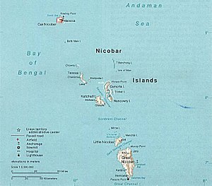
Camorta ( Nicobar : Kamorta ) is an Indian island and belongs to the Nicobar Islands in the Indian Ocean .
It is located 2.6 km west of the neighboring islands of Trinket , north 760 meters from Nancowry and 8 km east of Katchal . According to the Indian census in 2001, 2859 people lived on the island, the largest villages were: Kamorta / Kalatapu , Pilpilow , Kakana and Daring . At that time the island had an area of 188.2 km². In the south the island reaches a height of 186 meters.
An ideal natural harbor stretches between Nancowry and Camorta, which has been described as one of the safest natural harbors in the world and was known to Europeans as early as the 17th century. Pirates also frequently used this port until the English secured it with a base in 1869.
In October 1756 a Danish expedition under Volquart - after the failure on Groß Nikobar - set up a base on Camorta and took possession of the island as New Saatland ( Nye Sädland ). At that time it was uninhabited, the inhabitants of the neighboring island of Nancowry maintained a few fields with coconut , areca or betel nut palm trees. In addition to Europeans and Indians, Nicobarese came to the island, who soon sparked an uprising and drove the foreigners away.
Moravian missionaries reached the island in 1768, but moved on to Nancowry, which they considered more suitable. In 1778 the island was declared an Austrian crown colony by the Trieste East India Trade Company . In 1784 this claim was given up again.
Camorta was devastated in the great tidal waves of the tsunami as a result of the severe seaquake in the Indian Ocean in 2004 .
literature
- Franz Theodor Maurer: The Nicobars: Colonial history and description together with motivated proposals for the colonization of these islands by Prussia . Heymann, Berlin 1867, 320 pp.
Individual evidence
- ^ Page of the police with the island names ( memento of the original from March 27, 2010 in the Internet Archive ) Info: The archive link was automatically inserted and not yet checked. Please check the original and archive link according to the instructions and then remove this notice. (engl.)
- ^ Page of the police with the village name ( Memento of the original from May 25, 2011 in the Internet Archive ) Info: The archive link was inserted automatically and has not yet been checked. Please check the original and archive link according to the instructions and then remove this notice. (English)
- ↑ Sailing Directions (Enroute): India and the Bay of Bengal . (PDF; 4.0 MB) National Geospatial-Intelligence Agency, PUB. 173, Bethesda MD, Ninth Edition, p. 256
- ↑ Nicobar Islands . In: Encyclopædia Britannica . 11th edition. tape 19 : Mun - Oddfellows . London 1911, p. 660 (English, full text [ Wikisource ]).
- ↑ Maurer, p. 92
- ↑ Maurer, p. 100
- ↑ Maurer, p. 119

