Great Nicobar
| Great Nicobar | ||
|---|---|---|
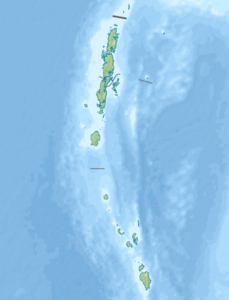
| Topographic map, the biosphere reserve is shown in green. | ||
| Waters | Indian Ocean | |
| Archipelago | Nicobar Islands | |
| Geographical location | 7 ° 5 ' N , 93 ° 48' E | |
|
|
||
| length | 55 km | |
| width | 28 km | |
| surface | 1 045 km² | |
| Highest elevation | Mount Thuillier 642 m |
|
| Residents | 9439 9 inhabitants / km² |
|
| main place | Campbell Bay | |
Great Nicobar Island ( English Great Nicobar , Hindi: बड़ा निकोबार , Bara Nicobar, nico Barisch : टोकिओंग लोंग or Tokieong Long ) is one of the Indian archipelago of the Nicobar Islands in the Bay of Bengal to the east lies the Andaman Sea . Politically, the island belongs to the Indian Andaman and Nicobar Union territory .
geography
It is only very sparsely populated with 9,439 inhabitants on 1,045 square kilometers . The island is the largest and southernmost of the Nicobar Islands, located over 600 km west of Malaysia and about 140 km north of the Indonesian island of Sumatra . A few kilometers north, across St.-Georg-Straße, lies the neighboring island of Klein Nikobar . Just off the western coast is the islet Megapod , and off the northern coast is Kondul .
The main town is Campbell Bay on the east coast, with 5,257 inhabitants, more than half of the island's population. There are also 25 other inhabited villages. The second largest town is Govind Nagar with 875 inhabitants.
The southernmost point of the island, Indira Point , also represents the southernmost point of India. The highest mountain, the Thuillier with 642 m, rises in the north of the island, a range of mountains stretches from here to the south. The rivers, including Alexandra, Amrit Kaur, Dogmar, and Galatea, flow mostly west and south.
history
Arab, Malay and Burmese ships called at the Nicobar Islands from the 7th century. In 1711 three French Jesuits from Pondicherry landed on the island and lived there for 30 months before moving on to Car Nicobar .
At the beginning of 1756 a Danish ship from Trankebar under Lieutenant Thanck reached the inhabited island, then also called Sianbalong , and took possession of it for Denmark. But of 150 men soon only 30 were still alive, the rest died of disease. The unsuccessful location of the settlement was blamed for the failure, although the disagreement and inappropriate behavior of the colonizers may also have played a role. The base was moved to Camorta in October 1756 .
In 1989, a large part of the island was placed under protection as a biosphere reserve.
Groß Nikobar was badly hit by the tsunami following the seaquake on December 26, 2004 .
population
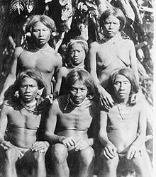
The Shompen people still have 400 speakers in the island's hinterland.
animals and plants
The island is home to a large number of ( endemic ) species that only occur here .
Important plant species are fig trees (Ficus), screw trees (Pandanus), stink trees (Sterculia), morning glories (Ipomea). The tree Nicobariodendron sleumeri only grows on this island . The tree fern Cyathea albosetacea and the orchid Phalaenopsis speciosa are unique and only found in the south of the island .
Important species include: saltwater crocodile (Crocodylus porosus), leatherback (Dermochelys coriacea), Nikobaren- tree shrews (Tupaia nicobarica) Amboina Box Turtle (Cuora amboinensis), reticulated python (Python reticulatus), Nicobar- Langschwanzmakak (Macaca fascicularis umbrosa), the sailors edible-nest swiftlet (Aerodramus fuciphagus, Syn .: Collocalia fuciphaga) and the decapods belonging coconut crab (Birgus latro).
Biosphere reserve
Approximately 85% of the island was established in January 1989 as a biosphere reserve provided "Great Nicobar Biosphere Reserve" under protection (on the map above right, it is shown in green). The core of the protected area covers approximately 885 km², surrounded by a 12 km wide buffer zone and consists of two parts: the larger Campbell Bay National Park in the north and the smaller Galathea Bay National Park in the interior of the island in the south.
The 15% island area that is not under protection is formed by the western and eastern coastal areas in the south of the island.
On May 28, 2013, the biosphere reserve was also recognized by UNESCO.
literature
Web link
- About the Biosphere (English)
Individual evidence
- ↑ Page of the police with the island names (English) ( Memento of the original from March 27, 2010 in the Internet Archive ) Info: The archive link was inserted automatically and has not yet been checked. Please check the original and archive link according to the instructions and then remove this notice.
- ↑ side of the police with data from 2001 (Engl.) ( Memento of the original on 21 July 2011 at the Internet Archive ) Info: The archive link is automatically inserted and not yet tested. Please check the original and archive link according to the instructions and then remove this notice.
- ↑ Archive link ( Memento of the original from July 28, 2012 in the web archive archive.today ) Info: The archive link was automatically inserted and not yet checked. Please check the original and archive link according to the instructions and then remove this notice.
- ↑ Maurer: Die Nicobaren, p. 90
- ^ Page of the biosphere reserve ( Memento of the original dated February 8, 2006 in the Internet Archive ) Info: The archive link was automatically inserted and has not yet been checked. Please check the original and archive link according to the instructions and then remove this notice.
- ^ Page of the biosphere reserve ( Memento of the original dated February 8, 2006 in the Internet Archive ) Info: The archive link was automatically inserted and has not yet been checked. Please check the original and archive link according to the instructions and then remove this notice.
- ↑ UNESCO includes eleven new biosphere reserves ( Memento of the original from August 21, 2013 in the Internet Archive ) Info: The archive link has been inserted automatically and has not yet been checked. Please check the original and archive link according to the instructions and then remove this notice.


