Car Nicobar
| Car Nicobar | ||
|---|---|---|
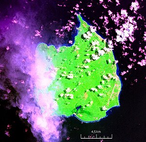
| NASA satellite image Geocover 2000 | ||
| Waters | Indian Ocean | |
| Archipelago | Nicobar Islands | |
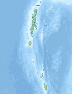
| Geographical location | 9 ° 10 ' N , 92 ° 46' E | |
|
|
||
| length | 15.9 km | |
| width | 13.1 km | |
| surface | 126.91 km² | |
| Highest elevation | 60 m | |
| Residents | 29,145 (2001) 230 inhabitants / km² |
|
| main place | Ha-nyôch (Mus) | |
| The village of Sawi in the northwest of the island (1895) | ||
Car Nicobar ( Nicobar : Pu ) belongs to the Indian archipelago of the Nicobars in the Bay of Bengal , in the east lies the Andaman Sea . Politically, the island belongs to the Indian Andaman and Nicobar Union territory .
The small island has an area of 126.9 square kilometers and a population of 29,145. It reaches a height of around 60 meters in the southwest. The largest places are Perka (2527), Malacca (1637), Mus (1553), Tamaloo (1515), Sawai (1247), Arong (1194) and Big Lapati / Jayanti (1098). Mus (Ha-nyôch) is the capital of the island and the seat of the Assistant Commissioner .
In each village, the Tuhet - a council - is elected from the elders who organize everyday life. The representative of the Nicobar district on the island is the Car Nicobar Tehsil . The uninhabited island of Batti Malv, 32 kilometers to the south, also belongs to Tehsil (roughly municipality) .
Car Nicobar is the northernmost of the Nicobar Islands, followed by Batti Malv. The next island further south, Chowra , already belongs to the Tehsil Nancowry .
Car Nicobar is 750 km from the epicenter of the seaquake of December 26, 2004 and was hit hard by the following tsunami - with waves up to 9 m high.
climate
| Car Nicobar | ||||||||||||||||||||||||||||||||||||||||||||||||
|---|---|---|---|---|---|---|---|---|---|---|---|---|---|---|---|---|---|---|---|---|---|---|---|---|---|---|---|---|---|---|---|---|---|---|---|---|---|---|---|---|---|---|---|---|---|---|---|---|
| Climate diagram | ||||||||||||||||||||||||||||||||||||||||||||||||
| ||||||||||||||||||||||||||||||||||||||||||||||||
|
Average monthly temperatures and rainfall for Car Nicobar
|
|||||||||||||||||||||||||||||||||||||||||||||||||||||||||||||||||||||||||||
Individual evidence
- ^ Page of the police with the island names ( memento of the original from March 27, 2010 in the Internet Archive ) Info: The archive link was automatically inserted and not yet checked. Please check the original and archive link according to the instructions and then remove this notice. (engl.)
- ↑ Island-wise Statistical Outline - 2008. CAR NICOBAR ISLAND ( page no longer available , search in web archives ) Info: The link was automatically marked as defective. Please check the link according to the instructions and then remove this notice. (PDF; English)
- ↑ Bay of Bengal Pilot - Bay of Bengal and the Coasts of India and Siam, Including the Nicobar and Andaman Islands , p. 284: 200 feet
- ↑ Census 2011
- ↑ Archive link ( Memento of the original from May 25, 2011 in the Internet Archive ) Info: The archive link was inserted automatically and has not yet been checked. Please check the original and archive link according to the instructions and then remove this notice.
- ^ National Geospatial Intelligence Agency: PUB. 173, Sailing Directions (Enroute): India and the Bay of Bengal, Bethesda, Maryland, Ninth Edition (PDF; 4.0 MB), p. 255
- ^ Andaman and Nicobar Islands, Administrative Divisions 2011


