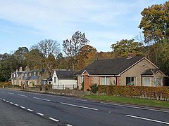
Camptown (Scottish Borders)
| Camptown | ||
|---|---|---|
| Buildings in Camptown | ||
| Coordinates | 55 ° 25 ′ N , 2 ° 30 ′ W | |
|
|
||
| administration | ||
| Post town | JEDBURGH | |
| ZIP code section | TD8 | |
| prefix | 01835 | |
| Part of the country | Scotland | |
| Council area | Scottish Borders | |
| British Parliament | Berwickshire, Roxburgh and Selkirk | |
| Scottish Parliament | Ettrick, Roxburgh and Berwickshire | |
Camptown is a hamlet in the south of the Scottish Council Area Scottish Borders or in the traditional county of Roxburghshire . It is located about eight kilometers south of Jedburgh and 17 kilometers east of Hawick on the right bank of the Jed Water .
history
The place name probably comes from a historical camp nearby. A tower house was probably built south of Camptown in the 16th century . A mansion was built on the same site as Edgerston House during the 17th century .
traffic
Camptown is just off the A68 ( Edinburgh - Darlington ). Around six kilometers to the south, the former Carter Bar border crossing marks the Scottish-English border.
Individual evidence
- ^ Entry in the Gazetteer for Scotland
- ↑ Camptown in: FH Groome (ed.): Ordnance Gazetteer of Scotland: A Survey of Scottish Topography, Statistical, Biographical and Historical , Grange Publishing Works, Edinburgh, 1882–1885.
- ↑ Listed Building - Entry . In: Historic Scotland .
Web links
Commons : Camptown - collection of pictures, videos and audio files

