A68 road
| A68 road in the UK | |

|
|
| |
|
| map | |
| Basic data | |
| Operator: | |
| Start of the street: |
Darlington ( 54 ° 32 ′ N , 1 ° 33 ′ W ) |
| End of street: |
Edinburgh ( 55 ° 55 ′ N , 3 ° 4 ′ W ) |
| Overall length: | 206 km (128 mi ) |
| Development condition: | 1 × 2 lanes |
| A68 in Northumberland | |
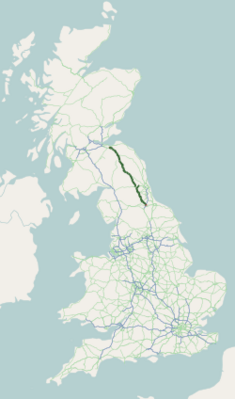
The A68 is a trunk road in the United Kingdom that runs from Darlington to the ring road in the Scottish capital, Edinburgh . As the primary route, it is part of the most important British trunk road network beneath the motorways.
course
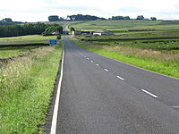
The road begins at the Northgate Roundabout roundabout on the northern edge of the old town of Darlington and leaves the city first in a north-westerly direction. Behind West Auckland the road turns more north, crosses the Tyne at Corbridge and from there runs in long straight sections through Northumberland to the Scottish border at Carter Bar , where it reaches its highest point at 418 m ASL . On the edge of the Northumberland National Park , it takes in Elishaw with the A696 road, a primary route coming from Newcastle upon Tyne , and in Scotland near Oxton with the A697 road , which comes from Morpeth . From the top of the Carter Bar pass, it descends again in a few curves and then runs in a steady north-north-westerly direction through a few smaller villages and towns to the City of Edinburgh Bypass ( A720 road ), the southern half-ring of the Scottish capital, which has been developed like a motorway.
Between Corbridge and Rochester and north of Jedburgh, the A68 follows the historic Dere Street in long sections and bears this name there.
expansion
A 4 km long southern section of the A68 (from Swan House Roundabout to the Darlington city limits) is built like a motorway with separate lanes. In this area the junction with the A1 (M) is at its junction no.58.
Apart from a few meters at junctions, the A68 has one lane in each direction of travel with a marked center line.
Conversions
- Corbridge
- Originally the street ran through the city center. Today she meets east of the city in a roundabout on the A69 , which has been developed as a bypass road , which she uses in a westerly direction for 4.7 km until it branches off north of Corbridge and then turns north again.
- Edinburgh
- For a long time the A68 ran through the city of Dalkeith outside the City of Edinburgh Bypass and on to the city center of Edinburgh. Today it bypasses Dalkeith to the east, the old section is now rededicated within the bypass to the A7 .
particularities
The border crossing of the A68 to Scotland on Carter Bar is by far the only one on a main trunk road; the closest border crossings for primary routes are the A697 at Coldstream (36 km northeast) and the A7 north of Carlisle (45 km southwest).
A well-known feature of the A68 is its numerous crests and valleys, especially in the rolling hills west of Newcastle upon Tyne .
From the City of Edinburgh Bypass to the junction of the A696 20 km south of the Anglo-Scottish border, the A68 is part of European route 15 .

