
Carter Bar
| Carter Bar | |||
|---|---|---|---|
 Travelers in the parking lot of Carter Bar |
|||
| Compass direction | northwest | Southeast | |
| Pass height | 418 m ASL | ||
| Scottish Borders , Scotland , United Kingdom | Northumberland , England , UK | ||
| Watershed | Jed Water | River speech | |
| Valley locations | Edgerston | Byrness | |
| expansion | Pass road | ||
| Mountains | Cheviot Hills | ||
| map | |||
|
|||
| Coordinates | 55 ° 21 '16 " N , 2 ° 28' 39" W | ||

Carter Bar is a pass at 418 m ASL in the Cheviot Hills . Here the A68 , a trunk road between Darlington and Edinburgh , crosses the Scottish-English border drawn in 1237. The nearest Scottish cities are Jedburgh , Hawick and Kelso , on the English side Byrness and Otterburn are not far.
history
In 1388 the Scottish Army crossed Carter Bar on the way to the Battle of Otterburn . In 1575 Carter Bar was the site of the Raid of the Redeswire , the last great battle between the kingdoms of England and Scotland.
tourism
At Carter Bar, the A68 has ample parking spaces on both sides. The border markings are bold in the form of oversized border stones and are a popular photo opportunity for travelers to Scotland.
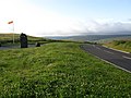
Carter Bar, 2009

Landmark
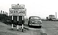
Carter Bar, 1960


Web links
- Scottish Borders Council: Carter Bar / Homecoming 2009 ( June 6, 2011 memento on the Internet Archive )
- Scottish Borders Council, windfarm proposal