Cape Flattery
| Cape Flattery | ||
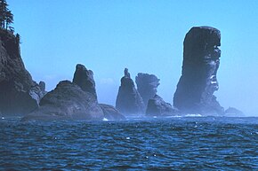
 The Fuca Pillar at Cape Flattery is the most northwestern point of Washington, USA |
||
| Geographical location | ||
|
|
||
| Coordinates | 48 ° 23 '5 " N , 124 ° 43' 35" W | |
| Waters 1 | Juan de Fuca street | |
| Waters 2 | Pacific Ocean | |
Cape Flattery is the Pacific Ocean located Chap . It marks the northwesternmost point of the geographically contiguous union of states of the United States of America ( Contiguous United States , excluding Alaska and Hawaii ).
The cape is located on the Olympic Peninsula in Clallam County , Washington state . This is where Juan de Fuca Street ends . Adjacent are the bays Makah Bay and Neah Bay.
The Cape Flattery Lighthouse is located on Tatoosh Island . The closest town is Neah Bay .
Web links
Commons : Cape Flattery - collection of images, videos and audio files
- Cape Flattery Trail (illustrated )
- Makah / Cape Flattery Trail ( Memento from December 17, 2009 in the Internet Archive )
