Capitol Peak (Thurston County)
| Capitol Peak | ||
|---|---|---|
| height | 812 m (North American Vertical Date of 1988) | |
| location | Thurston County , Washington , USA | |
| Mountains | Black Hills | |
| Notch height | 132 m | |
| Coordinates | 46 ° 58 '22 " N , 123 ° 8' 20" W | |
|
|
||
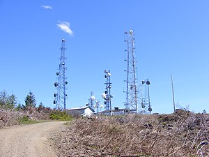
The Capitol Peak is a mountain in the Black Hills in the State of Washington . It forms the highest point in the Black Hills. Capitol Peak is located in the Capitol State Forest . There is a partially paved road, Sherman Valley Road, which leads to the summit. There is a property on the summit that houses a large number of cell phone and radio masts. On a clear day, Elma and the Satsop nuclear power station can be seen in the west ; to the east there is a view of Mount Rainier , Mount St. Helens , Mount Adams , Puget Sound and the Olympia area .
Individual evidence
- ↑ Capitol Peak LOT . National Geodetic Survey. Retrieved January 23, 2019.
Web links
- Capitol Peak ( English ) In: Geographic Names Information System . United States Geological Survey . Retrieved December 7, 2008.
- Capitol Peak, Washington . PeakBagger.com. Retrieved December 1, 2008.

