
Carl Wark

Carl Wark (also Carl's Wark) is a hill fort on a rocky promontory made of sandstone , on Hathersage Moor, about 3.0 kilometers east of Hathersage in the Peak District , on the border of Sheffield , in South Yorkshire in England .
The Hillfort is an outcrop surrounded on three sides by vertical cliffs, the fourth side is formed by a prehistoric wall. The enclosure has been interpreted as being from the Iron Age , although the date and purpose of the fortification are unknown. The south-east-north-west oriented promontory is about 230 meters long and 60 meters wide. It slopes gently to the west; On the summit there is an area of 0.7 hectares about 180 meters long and 60 meters wide. The eastern and north-eastern sides are formed by vertical cliffs up to 10 meters high. The southern edge consists of large earth-solid boulders, which with loose blocks form a wall 2 to 2.5 meters high. A rampart about 40 meters long, 8.0 meters wide at the base and 3.0 meters high at the western end of the foothills completes the complex. The wall consists of an earth wall, which is clad on the outside with Cyclopean sandstone blocks. In the south wall, about 10 meters from the Siegfried Line, there is a 2.0 meter wide, curved entrance through the rock face with walls 2.5 m high on both sides.
At the southern end of the wall there are remains of a refuge that was built from stones from the wall. At the eastern end of the promontory there is evidence of millstone production around the foot of the cliff , which probably took place in the 16th or 17th century.
- Carl Wark
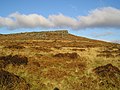
From the south
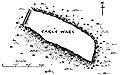
plan
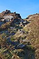
Access

In the background over Higger Tor

The Cyclops Wall
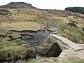
Bridge on the Pacting Path


Although this site is believed to date back to the Iron Age, it is located in an area rich in Bronze Age remains, including the Cairns , Ring Cairns, and Field Systems. It could well be that Carl Wark, which structurally does not fit the recognized Iron Age Hillforts, was built as early as the Neolithic .
Line of sight is between Carl Wark and the hill fort of Mam Tor about 10 miles to the west .
The origin of the name Carl Wark is uncertain. Rooke used the name "Cair's Work" in his 1785 description, while Bateman used "Carleswark". Sheffield historian SO Addy, who wrote in 1893, claimed that the name was Old Norse and meant "old man's fort," with the "old man" referring to the devil and the 9th to 10th centuries. The 1802 Derbyshire edition of The Beauties of England and Wales refers to a rock on the site called "Cair's Chair" which suggests the Welsh word "Caer" for fort or wall as a possible origin - Cair is one old spelling.
Web links
- Description Engl. and picture
- Description Engl. and picture
- Video
- Video
- Video
- Description Engl. and picture
- Description Engl. and pictures
Coordinates: 53 ° 19 ′ 46 ″ N , 1 ° 36 ′ 46 ″ W.