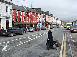
Carrickmacross
| Carrickmacross Carraig Mhachaire Rois |
|||

|
|||
| location | |||
| Coordinates: | 53 ° 59 ′ N , 6 ° 43 ′ W | ||
|
|||
| Data | |||
| Province: | Ulster | ||
| County: | Monaghan | ||
| Height: | 44 m above sea level NHN | ||
| Residents: | 2,000 (2006) | ||
Carrickmacross ( Irish : Carraig Mhachaire Rois; German about: "The rock in the wooded plain") is a town in County Monaghan in the east of the Republic of Ireland .
The place
Carrickmacross is a small market town in the south of County Monaghan, near Counties Louth and Cavan and on the border with Northern Ireland , which developed around a castle built in 1630 by an Earl of Essex , now defunct. In the 2006 census , including the rural area, 5066 residents were counted, of which around 2000 live in the town itself. There are three primary and three secondary schools each in Carrickmacross. There is a town partnership with Carhaix-Plouguer in Brittany .
traffic
Carrickmacross is about 18 km northwest of Ardee on the N2 national road from Dublin to Monaghan Town . Dundalk on Ireland's east coast is about 20 km away as the crow flies. The place has not been connected to rail traffic in Ireland since 1960.
Web links
Individual evidence
- ↑ Map of Ireland (can be enlarged greatly) ( Memento of the original from February 21, 2015 in the Internet Archive ) Info: The archive link has been inserted automatically and has not yet been checked. Please check the original and archive link according to the instructions and then remove this notice.

