
Carhaix-Plouguer
|
Carhaix-Plouguer Karaez-Plougêr |
||
|---|---|---|
.svg)
|
|
|
| region | Brittany | |
| Department | Finistère | |
| Arrondissement | Chateaulin | |
| Canton | Carhaix-Plouguer | |
| Community association | Poher Community | |
| Coordinates | 48 ° 17 ′ N , 3 ° 34 ′ W | |
| height | 69-169 m | |
| surface | 25.81 km 2 | |
| Residents | 7,174 (January 1, 2017) | |
| Population density | 278 inhabitants / km 2 | |
| Post Code | 29270 | |
| INSEE code | 29024 | |
| Website | http://www.ville-carhaix.com/ | |
 Maison du Sénéchal, tourist office |
||

Carhaix-Plouguer ( Breton Karaez-Plougêr ) is a French commune in Brittany in the Finistère department with 7,174 inhabitants (as of January 1, 2017).
geography
The place is centrally located in the west of Brittany. Quimper is around 50 kilometers southwest, the city and port of Brest 68 kilometers northwest and Paris 450 kilometers east (as the crow flies ). The northern municipal boundary is the Hyère river .
history
Carhaix goes back to the Roman Vorgium , which is also known from excavations. It was the provincial capital of the Osismians . The settlement had a Gallic predecessor settlement, the first remains of which date from the 4th century. The Romanesque church of Saint-Pierre de Plouguer , the oldest construction phase of which dates back to the 11th century, is an important attraction of the municipality . The Church of St. Tremeur was founded in the 14th century, the current building largely dates from the 19th century.
Today's municipality was created in 1956 from the merger of the previously independent municipalities of Carhaix and Plouguer .
Population development
| year | 1962 | 1968 | 1975 | 1982 | 1990 | 1999 | 2007 | 2017 |
| Residents | 6065 | 7049 | 8210 | 8591 | 8198 | 7648 | 7667 | 7174 |
| Sources: Cassini and INSEE | ||||||||
traffic
Carhaix-Plouguer lies at the intersection of several national connecting roads. At Landivisiau , Morlaix and Guingamp in the north there are exits on the expressway E 50 Brest- Rennes and at Quimper and Lorient in the south on the E 60 Brest- Nantes . There are also train stations on the predominantly parallel regional railway lines . Brest train station is the terminus of the TGV Atlantique to Paris.
Carhaix-Plouguer was originally the center of an extensive network of narrow-gauge railways , the Réseau Breton . Almost all lines of the Réseau Breton were shut down and dismantled in 1967. Only the route to Guingamp was retained and retraced to standard gauge . On her run TER trains to Guingamp.
The airports Aéroport de Brest Bretagne near Brest and Aéroport de Lorient Bretagne Sud near Lorient are the nearest regional airports .
Attractions
- Saint-Trémeur church
- Saint-Pierre church in Plouguer
See also: List of Monuments historiques in Carhaix-Plouguer

Saint-Pierre church in Plouguer
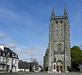
Saint-Trémeur church

Portal of the Sainte-Anne chapel

Couvent des Hospitalières
_%C3%89glise_Saint-Pierre_de_Plouguer_04.JPG)
_%C3%89glise_Saint-Tr%C3%A9meur_03.JPG)
.JPG)

Personalities
- Théophile-Malo de La Tour d'Auvergne-Corret (1743–1800), "the first grenadier", a well-known antiquarian
- Maxime-Julien Émeriau de Beauverger (1762-1845), admiral
Culture
Every July since 1991, Carhaix has hosted the multi-day Festival des Vieilles Charrues , which is the largest music festival in France based on the number of spectators (240,000 in 2011).
In 1999 the first and so far only Diwan high school was relocated from Relecq-Kerhuon (near Brest ) to Carhaix-Plouguer.
The municipality has signed up to the Ya d'ar brezhoneg charter to promote the Breton language. In February 2016, it was the only community certified according to this charter to the highest level 4.
Community partnerships
Carhaix-Plouguer is in partnership with:
- the south-west English seaside resort of Dawlish
- Oiartzun in the Basque Country , Spain
- Waldkappel , North Hesse , Germany
- Carrickmacross , Republic of Ireland
- Rijnwoude , the Netherlands
- El Arroub , Palestine
literature
- Le Patrimoine des Communes du Finistère. Flohic Editions, Volume 1, Paris 1998, ISBN 2-84234-039-6 , pp. 137-149.
Web links
Individual evidence
- ↑ Madeleine Reincke, Anja Schliebitz, Hilke Maunder , Baedeker Allianz Travel Guide Bretagne, Ostfildern 2006, 154
- ↑ http://vorgium.pagesperso-orange.fr/accueil.htm
- ↑ Madeleine Reincke, Anja Schliebitz, Hilke Maunder, Baedeker Allianz Travel Guide Bretagne, Ostfildern 2006, 153